IMAGES TAKEN NEAR TO
Heol Cefn Ydfa, BRIDGEND, CF32 0DU
Introduction
This page details the photographs taken nearby to Heol Cefn Ydfa, CF32 0DU by members of the Geograph project.
The Geograph project started in 2005 with the aim of publishing, organising and preserving representative images for every square kilometre of Great Britain, Ireland and the Isle of Man.

There are currently over 7.5m images from over14,400 individuals and you can help contribute to the project by visiting https://www.geograph.org.uk
Image Map
Images are licensed for reuse under creativecommons.org/licenses/by-sa/2.0
Notes
- Clicking on the map will re-center to the selected point.
- The higher the marker number, the further away the image location is from the centre of the postcode.
Image Listing (53 Images Found)
Images are licensed for reuse under creativecommons.org/licenses/by-sa/2.0
Image
Details
Distance
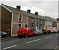
1
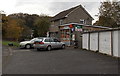
Coytrahen Stores & Post Office
There is a Business Lease for Sale notice on the premises in Heol Cefn Ydfa in late October 2014.
Image: © Jaggery
Taken: 28 Oct 2014
0.04 miles
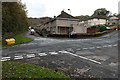
2
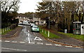
Towards Heol Coed Leyshon in Coytrahen
Viewed across the A4063 Maesteg Road. The road leads to houses in Heol Coed Leyshon,
Heol Treharne and Heol Coed Ydfa, which is also the location of the village post office. http://www.geograph.org.uk/photo/4223606
Image: © Jaggery
Taken: 28 Oct 2014
0.04 miles
3
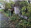
Two boxes in Heol Cefn Ydfa, Coytrahen
The green telecoms box and grey electricity substation are near the village stores and post office. http://www.geograph.org.uk/photo/4223606
Image: © Jaggery
Taken: 28 Oct 2014
0.04 miles
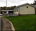
4
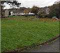
Playground near Coytrahen Community Centre
On the south side of the community centre. http://www.geograph.org.uk/photo/4224023
Image: © Jaggery
Taken: 28 Oct 2014
0.04 miles
5
Residential crossroads in Coytrahen
Viewed from Heol Coed Ydfa looking across Heol Coed Leyshon towards Heol Treharne.
Image: © Jaggery
Taken: 28 Oct 2014
0.05 miles
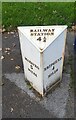
7
Old Milestone by the A4063, Coytrah?n, Llangynwyd Lower parish
Milestone by the A4063, in parish of Llangynwyd Lower (Bridgend County Borough District), Coytrahên, centre of village, West side of road, next to bus shelter.
Inscription reads:-
: MAESTEG / 5 / MILES : : RAILWAY / STATION / 4¼ : : BRIDGEND / 4 / MILES :
Surveyed
Milestone Society National ID: GLA_MSBE05
Image: © Milestone Society
Taken: Unknown
0.06 miles
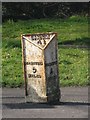
8
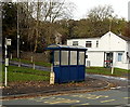
Milestone and bus shelter in Coytrahen
Viewed across the A4063 Maesteg Road. The face of the milestone in view shows MAESTEG 5.
Image: © Jaggery
Taken: 28 Oct 2014
0.07 miles
9
Royal Mail van in Coytrahen
Viewed across the A4063 Maesteg Road. The name sign on the left shows VICTORIA BUILDINGS.
Image: © Jaggery
Taken: 28 Oct 2014
0.07 miles
10
Coytrahen Community Centre
Set back 30 metres from the east side of A4063 Maesteg Road.
Coytrahen Community Centre is also known as the Phillip Squire Centre.
Image: © Jaggery
Taken: 28 Oct 2014
0.07 miles