IMAGES TAKEN NEAR TO
Bedford Road, BRIDGEND, CF32 0BW
Introduction
This page details the photographs taken nearby to Bedford Road, CF32 0BW by members of the Geograph project.
The Geograph project started in 2005 with the aim of publishing, organising and preserving representative images for every square kilometre of Great Britain, Ireland and the Isle of Man.

There are currently over 7.5m images from over14,400 individuals and you can help contribute to the project by visiting https://www.geograph.org.uk
Image Map
Images are licensed for reuse under creativecommons.org/licenses/by-sa/2.0
Notes
- Clicking on the map will re-center to the selected point.
- The higher the marker number, the further away the image location is from the centre of the postcode.
Image Listing (34 Images Found)
Images are licensed for reuse under creativecommons.org/licenses/by-sa/2.0
Image
Details
Distance
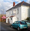
1
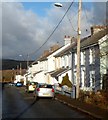
Bedford Road houses, Cefn Cribwr
A view north along Bedford Road, looking in the direction of the White Lion pub. http://www.geograph.org.uk/photo/3268308
There are no houses on the opposite side of the road here.
Image: © Jaggery
Taken: 7 Dec 2012
0.01 miles
2
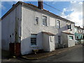
White Lion pub viewed from the north, Cefn Cribwr
The pub is at 24 Bedford Road.
Image: © Jaggery
Taken: 7 Dec 2012
0.04 miles
3
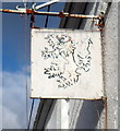
White Lion pub sign, Cefn Cribwr
The heraldic lion sign hangs from a wall bracket here. http://www.geograph.org.uk/photo/3268308
Image: © Jaggery
Taken: 7 Dec 2012
0.05 miles
4
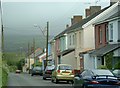
Bedford Road
Cottages at north of Cefn Cribwr.
Image: © Chris Shaw
Taken: Unknown
0.05 miles
5
White Lion pub viewed from the south, Cefn Cribwr
The pub is at 24 Bedford Road.
Image: © Jaggery
Taken: 7 Dec 2012
0.06 miles
6
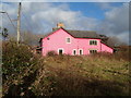
A pink house, Bedford Road, Cefn Cribwr
This is the first house north of the White Lion. http://www.geograph.org.uk/photo/3268308
Image: © Jaggery
Taken: 7 Dec 2012
0.09 miles
7
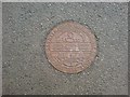
Llynfi & Porth Cawl Railway Company plaque
A small plaque is placed in the tarmac of the cycle path to celebrate the previous use of this route, which was once a mineral railway to Porth Cawl, servicing some of the collieries further up the valley.
Image: © Hywel Williams
Taken: 6 Aug 2009
0.11 miles
8
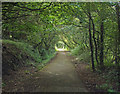
Path at Bedford Park/Parc Bedford, Cefn Cribwr
A photograph taken at the end of a woodland path which runs westwards from Bedford Road, Cefn Cribwr to Kenfig Hill over a distance of about a mile. The path follows the course of the dismantled Dyffryn, Llynfi and Porthcawl Railway, and both National Cycle Route 4 and the Tondu to Pyle Community Route pass along it.
Image: © eswales
Taken: 5 Aug 2011
0.14 miles
9

A view north from a Cefn Cribwr hillside
Woodland in Cwm Ffos lies immediately beyond the grass-covered slope in the foreground. Mynydd Baedan – whose top in Image lies three kilometres from the camera – dominates the background of the left half of the image. A former opencast mining site lies between the two.
Image: © eswales
Taken: 15 Jun 2022
0.16 miles
10
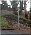
Steps from Bedford Road up to a footpath, Cefn Cribwr
A signpost showing a footpath points towards the steps on the west side of Bedford Road.
Image: © Jaggery
Taken: 7 Dec 2012
0.16 miles