IMAGES TAKEN NEAR TO
Heol Shon, BRIDGEND, CF32 0BG
Introduction
This page details the photographs taken nearby to Heol Shon, CF32 0BG by members of the Geograph project.
The Geograph project started in 2005 with the aim of publishing, organising and preserving representative images for every square kilometre of Great Britain, Ireland and the Isle of Man.

There are currently over 7.5m images from over14,400 individuals and you can help contribute to the project by visiting https://www.geograph.org.uk
Image Map
Images are licensed for reuse under creativecommons.org/licenses/by-sa/2.0
Notes
- Clicking on the map will re-center to the selected point.
- The higher the marker number, the further away the image location is from the centre of the postcode.
Image Listing (53 Images Found)
Images are licensed for reuse under creativecommons.org/licenses/by-sa/2.0
Image
Details
Distance
1
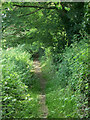
A short public footpath in Cefn Cribwr
Part of a public footpath, approximately 200 metres in length, which runs westwards from Bedford Road. The path runs beside a line of broadleaf trees and provides some good views to the north.
Image: © eswales
Taken: 15 Jun 2022
0.04 miles
2
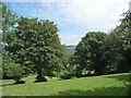
Broadleaf trees on a Cefn Cribwr hillside
Broadleaf trees and a field adjacent to the footpath seen in Image
Image: © eswales
Taken: 15 Jun 2022
0.06 miles
3
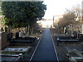
Gravestones line the entrance to Nebo chapel, Cefn Cribwr
Viewed from the northern edge of the chapel http://www.geograph.org.uk/photo/3268115 looking towards Cefn Road.
Gravestones also occupy most of the area surrounding the chapel.
Image: © Jaggery
Taken: 7 Dec 2012
0.07 miles
4
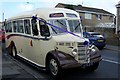
Bus at the Chapel, Cefn Road, Cefn Cribwr
Image: © Terry Robinson
Taken: 11 Sep 2010
0.07 miles
5
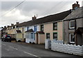
Houses on the south side of Cefn Road, Cefn Cribwr
A view east from the corner of Heol Shon. http://www.geograph.org.uk/photo/3267715
The B4281 Cefn Road is the main road through the village.
Image: © Jaggery
Taken: 7 Dec 2012
0.07 miles
6
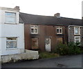
Derelict house, Cefn Road, Cefn Cribwr
Viewed across the B4281 Cefn Road, the main road through the village.
The house's ground floor windows are boarded up and some of the upstairs panes are broken.
Image: © Jaggery
Taken: 7 Dec 2012
0.07 miles
7
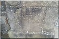
Ordnance Survey Cut Mark
This OS cut mark can be found on the gatepost of Capel Nebo. It marks a point 127.692m above mean sea level.
Image: © Adrian Dust
Taken: 3 Sep 2021
0.08 miles
8
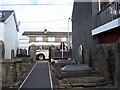
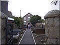
Path from the Chapel, Cefn Road, Cefn Cribwr
The Bedford 'Nostalgia Bus' waits patiently to take the wedding party to the reception hotel ... and one of the photographers enjoys a break! Image Image Image Image
Image: © Terry Robinson
Taken: 11 Sep 2010
0.08 miles
9
Path to the Chapel, Cefn Road, Cefn Cribwr
Image: © Terry Robinson
Taken: 11 Sep 2010
0.08 miles
10
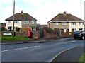
Heol Shon houses, Cefn Cribwr
Viewed from the corner of the B4281, the main road through the village.
The street name sign shows that Heol Shon leads to streets named Gwelfor and Heol Castell.
Image: © Jaggery
Taken: 7 Dec 2012
0.08 miles