1
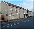
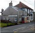
Royal British Legion, Cefn Cribwr
The Royal British Legion Club & Institute is on the north side of the B4281 Cefn Road,
the main road through the village. At the left edge of the view is part of the former Cefn Cribwr War Memorial. http://www.geograph.org.uk/photo/3274381
Image: © Jaggery
Taken: 7 Dec 2012
0.02 miles
2
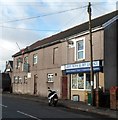
Cefn News & Off Licence, Cefn Cribwr
The shop occupies the eastern side of the building which also has the Royal British Legion Club & Institute http://www.geograph.org.uk/photo/3274361 located on the north side of the B4281 Cefn Road, the main road through the village.
Image: © Jaggery
Taken: 7 Dec 2012
0.02 miles
3
Former Cefn Cribwr War Memorial
The unusual location for the former War Memorial is on a bus stop on the north side of the B4281 Cefn Road, the main road through the village. The location was appropriate in that the Royal British Legion building http://www.geograph.org.uk/photo/3274361 is next door, out of shot on the right.
A new War Memorial http://www.geograph.org.uk/photo/3267547 was erected nearby in 2012.
Image: © Jaggery
Taken: 7 Dec 2012
0.03 miles
4
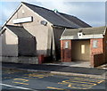
Cefn Cribwr Athletic Club
On the corner of Cefn Road and Bedford Road, opposite the Three Horse Shoes pub. http://www.geograph.org.uk/photo/3268169
Image: © Jaggery
Taken: 7 Dec 2012
0.03 miles
5
Public footpath to a hillside at Cefn Cribwr
The path runs from Cefn Road (B4281) to the hillside seen in the foreground in
Image] - and beyond according to OS maps although this was not attempted on the day.
Image: © eswales
Taken: 15 Jun 2022
0.03 miles
6
Bedford Close, Cefn Cribwr
Bedford Close is a short cul-de-sac on the east side of Bedford Road.
Image: © Jaggery
Taken: 7 Dec 2012
0.03 miles
7
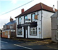
Three Horse Shoes pub, Cefn Cribwr
The pub is on the south side of the B4281 Cefn Road, the main road through the village, facing Bedford Road. At the early December 2012 date of this view, there was a For Sale board on the pub.
The smaller building on the left is Cefn Chinese Takeaway. http://www.geograph.org.uk/photo/3268184
Image: © Jaggery
Taken: 7 Dec 2012
0.04 miles
8
Cefn Cribwr (West)
Looking East along Cefn Road towards the village centre
Image: © Chris Shaw
Taken: Unknown
0.04 miles
9
Northern end of Ty Isaf Road, Cefn Cribwr
Looking towards the T-junction with the B4281 Cefn Road, the main road through the village.
Image: © Jaggery
Taken: 7 Dec 2012
0.04 miles
10
Cefn Chinese Takeaway, Cefn Cribwr
The takeaway is located on the south side of the B4281 Cefn Road,the main road through the village, opposite the Bedford Road junction. The Three Horse Shoes pub http://www.geograph.org.uk/photo/3268169 is next door.
Image: © Jaggery
Taken: 7 Dec 2012
0.04 miles


