IMAGES TAKEN NEAR TO
Cefn Road, BRIDGEND, CF32 0AE
Introduction
This page details the photographs taken nearby to Cefn Road, CF32 0AE by members of the Geograph project.
The Geograph project started in 2005 with the aim of publishing, organising and preserving representative images for every square kilometre of Great Britain, Ireland and the Isle of Man.

There are currently over 7.5m images from over14,400 individuals and you can help contribute to the project by visiting https://www.geograph.org.uk
Image Map
Images are licensed for reuse under creativecommons.org/licenses/by-sa/2.0
Notes
- Clicking on the map will re-center to the selected point.
- The higher the marker number, the further away the image location is from the centre of the postcode.
Image Listing (25 Images Found)
Images are licensed for reuse under creativecommons.org/licenses/by-sa/2.0
Image
Details
Distance
1
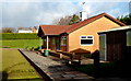
Bowls pavilion, Cefn Cribwr
The pavilion is inside the bowls club http://www.geograph.org.uk/photo/3275555 in Cae Gof recreation ground.
Image: © Jaggery
Taken: 7 Dec 2012
0.05 miles
2
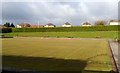
Bowling green, Cefn Cribwr
The bowling green is part of Cefn Cribwr Athletic Bowls Club located in Cae Gof recreation area.
Image: © Jaggery
Taken: 7 Dec 2012
0.05 miles
3
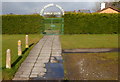
Entrance to Cefn Cribwr Athletic Bowls Club
This is part of the Cae Gof recreation ground located on the south side of the B4281 Cefn Road, the main road through the village.
Image: © Jaggery
Taken: 7 Dec 2012
0.06 miles
4
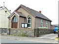
Calvary Baptist Chapel
Calvary Baptist Chapel, Cefn Cribwr.
Image: © Alan Hughes
Taken: 7 Jun 2016
0.08 miles
5
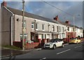
Pleasant View, Cefn Cribwr
Pleasant View is a row of 8 houses on the north side of the B4281 Cefn Road, the main road through the village.
Image: © Jaggery
Taken: 7 Dec 2012
0.08 miles
6
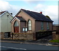
Calvary Baptist Chapel, Cefn Cribwr
The small chapel was built in 1907 on the north side of Cefn Road, opposite the Greenmeadow junction.
Image: © Jaggery
Taken: 7 Dec 2012
0.08 miles
7
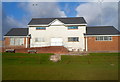
Sports pavilion, Cae Gof recreation area, Cefn Cribwr
The pavilion is alongside a football pitch and a rugby pitch.
Image: © Jaggery
Taken: 7 Dec 2012
0.08 miles
8
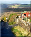
The Graig, Cefn Cribwr
Viewed from the corner of John Street. The lane named The Graig descends towards Waun Dafydd Farm.
Image: © Jaggery
Taken: 7 Dec 2012
0.09 miles
9
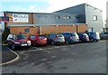
BCLC, Cefn Cribwr
BCLC is Bethlehem Church Life Centre, which opened in Cefn Cribwr in 2005. It is located on the south side of the B4281 Cefn Road, the main road through the village.
Image: © Jaggery
Taken: 7 Dec 2012
0.12 miles
10
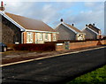
Bryn Glas bungalows, Cefn Cribwr
A view east from the corner of The Graig. The course of Bryn Glas is on the north side of Cefn Road and parallel with it.
Image: © Jaggery
Taken: 7 Dec 2012
0.12 miles