IMAGES TAKEN NEAR TO
Trowbridge Road, CARDIFF, CF3 1QJ
Introduction
This page details the photographs taken nearby to Trowbridge Road, CF3 1QJ by members of the Geograph project.
The Geograph project started in 2005 with the aim of publishing, organising and preserving representative images for every square kilometre of Great Britain, Ireland and the Isle of Man.

There are currently over 7.5m images from over14,400 individuals and you can help contribute to the project by visiting https://www.geograph.org.uk
Image Map
Images are licensed for reuse under creativecommons.org/licenses/by-sa/2.0
Notes
- Clicking on the map will re-center to the selected point.
- The higher the marker number, the further away the image location is from the centre of the postcode.
Image Listing (34 Images Found)
Images are licensed for reuse under creativecommons.org/licenses/by-sa/2.0
Image
Details
Distance
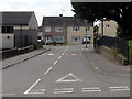
1
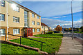
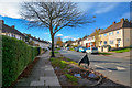
Cardiff : Trowbridge Road
Looking along Trowbridge Road in Cardiff.
Image: © Lewis Clarke
Taken: 14 Nov 2018
0.07 miles
2
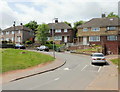
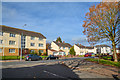
Letterston Road, Cardiff
Houses at the eastern end of Letterston Road, viewed from the corner of Greenway Road.
Image: © Jaggery
Taken: 20 May 2010
0.09 miles
3
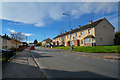
Cardiff : Aberdaron Road
Looking along Aberdaron Road.
Image: © Lewis Clarke
Taken: 14 Nov 2018
0.09 miles
4
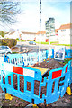
Cardiff : Harris Avenue
The local waterboard has dug the road up.
Image: © Lewis Clarke
Taken: 14 Nov 2018
0.09 miles
5
Cardiff : Harris Avenue
Looking along Harris Avenue.
Image: © Lewis Clarke
Taken: 14 Nov 2018
0.10 miles
6
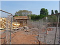
Construction site in St Mellons
A footpath through the building site it maintained. The site of Cae Castell / Rumney Castle is marked by the trees at the end.
Image: © Gareth James
Taken: 23 Apr 2011
0.12 miles
7
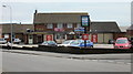
The Newbridge, Trowbridge, Cardiff
Pub located on the corner of Abergele Road and Borth Road. The pub was built c1966, which ties in with the pub sign, which shows the Severn Bridge, built in 1966. Locally, for many years afterwards, the Severn Bridge was often referred to as 'the new bridge'
Image: © Jaggery
Taken: 20 May 2010
0.13 miles
8
Cardiff : Aberdaron Road
Looking towards Aberdaron Road from Brynbala Way.
Image: © Lewis Clarke
Taken: 14 Nov 2018
0.13 miles
9
South along Borth Road, Trowbridge, Cardiff
From Abergele Road along Borth Road towards Caernarvon Way in the Trowbridge area of Cardiff.
Image: © Jaggery
Taken: 22 Jun 2017
0.13 miles
10
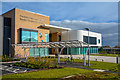
Cardiff : Eastern Community Campus
Eastern High School (formerly Rumney High School) is an English medium co-educational, community school in the Rumney area of Cardiff, Wales. The school serves the communities of Rumney, Llanrumney, Trowbridge and St Mellons on the eastern side of Cardiff and was opened in the 1950s alongside Llanrumney High School.
Image: © Lewis Clarke
Taken: 14 Nov 2018
0.15 miles