IMAGES TAKEN NEAR TO
Banc Gwyn, BRIDGEND, CF31 5DJ
Introduction
This page details the photographs taken nearby to Banc Gwyn, CF31 5DJ by members of the Geograph project.
The Geograph project started in 2005 with the aim of publishing, organising and preserving representative images for every square kilometre of Great Britain, Ireland and the Isle of Man.

There are currently over 7.5m images from over14,400 individuals and you can help contribute to the project by visiting https://www.geograph.org.uk
Image Map
Images are licensed for reuse under creativecommons.org/licenses/by-sa/2.0
Notes
- Clicking on the map will re-center to the selected point.
- The higher the marker number, the further away the image location is from the centre of the postcode.
Image Listing (5 Images Found)
Images are licensed for reuse under creativecommons.org/licenses/by-sa/2.0
Image
Details
Distance
1
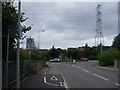
Roundabout and Pylon
Roundabout on B4622. Electricity lines, with pylon, running parallel at this point near Broadlands.
Image: © Colin Pyle
Taken: 6 Aug 2008
0.04 miles
2
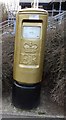
Gold Box on Gentle way, Bridgend
Gold Box for Aled Davies win in Athletics - Men's Discus F42
Image: © Kit Slater
Taken: 27 Mar 2013
0.19 miles
3
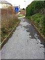
Cycle Track
Cycle track in Broadlands, Bridgend.
Image: © Alan Hughes
Taken: 10 Feb 2016
0.23 miles
4
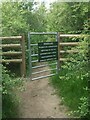
Gate at the southern end of a permissive path, Broadlands
This gate is a very short distance north of Bypass Road – the A48 - at the side of the public footpath which runs along the eastern edge of Broadlands in Bridgend. The permissive path which starts here is not shown on Ordnance Survey maps, but satellite photography online shows it running to Celestial Way, a nearby road (with a church) in the south of Broadlands.
Image: © eswales
Taken: 8 Jun 2021
0.23 miles
5
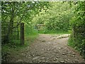
Gateway on public footpath by the south east corner of Broadlands, Bridgend
Situated immediately to the north of the A48 Bypass Road on the public footpath which runs along the eastern boundary of Broadlands. A waymarker on the left gatepost points along the public footpath. To the left of the path at the point where it turns a gate with a notice can be seen. This gate, which is situated at the southern end of a permissive path, is shown in Image The kissing gate seen next to the left gatepost presumably sees little use these days.
Image: © eswales
Taken: 8 Jun 2021
0.25 miles