IMAGES TAKEN NEAR TO
Heol Y Deryn Ddu, BRIDGEND, CF31 4UD
Introduction
This page details the photographs taken nearby to Heol Y Deryn Ddu, CF31 4UD by members of the Geograph project.
The Geograph project started in 2005 with the aim of publishing, organising and preserving representative images for every square kilometre of Great Britain, Ireland and the Isle of Man.

There are currently over 7.5m images from over14,400 individuals and you can help contribute to the project by visiting https://www.geograph.org.uk
Image Map
Images are licensed for reuse under creativecommons.org/licenses/by-sa/2.0
Notes
- Clicking on the map will re-center to the selected point.
- The higher the marker number, the further away the image location is from the centre of the postcode.
Image Listing (104 Images Found)
Images are licensed for reuse under creativecommons.org/licenses/by-sa/2.0
Image
Details
Distance
1
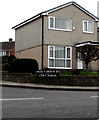
Mostly Welsh, partly English, name sign on a Bridgend corner
Facing Barnes Avenue here, https://www.geograph.org.uk/photo/5984869 the sign shows HEOL Y DERYN DU Leading to LÔN Y BUGAIL.
Image: © Jaggery
Taken: 21 Nov 2018
0.01 miles
2
Corner of Llangewydd Road and Barnes Avenue, Bridgend
Viewed across Llangewydd Road.
Image: © Jaggery
Taken: 16 Nov 2018
0.02 miles
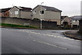
3
Southern end of Barnes Avenue, Bridgend
Looking north from Llangewydd Road.
Image: © Jaggery
Taken: 16 Nov 2018
0.02 miles
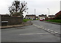
4
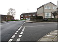
Junction of Barnes Avenue and Heol y Deryn Du, Bridgend
From the right, Heol y Deryn Du joins Barnes Avenue.
The name sign https://www.geograph.org.uk/photo/5984878 shows that Heol y Deryn Du leads to Lôn y Bugail.
Image: © Jaggery
Taken: 21 Nov 2018
0.02 miles
5
Southern end of Barnes Avenue, Bridgend
From the left, Barnes Avenue joins Llangewydd Road.
Image: © Jaggery
Taken: 21 Nov 2018
0.02 miles
6
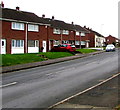
Houses on the south side of Llangewydd Road, Bridgend
Viewed from the corner of Barnes Avenue.
Image: © Jaggery
Taken: 21 Nov 2018
0.04 miles
7
Heol y Blodau, Bridgend
Heol y Blodau is a cul-de-sac on the east side of Barnes Avenue.
Image: © Jaggery
Taken: 21 Nov 2018
0.05 miles
8
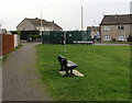
Bench on the north side of Llangewydd Road, Bridgend
At the edge of this https://www.geograph.org.uk/photo/5984914 grass triangle.
Image: © Jaggery
Taken: 21 Nov 2018
0.05 miles
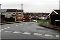
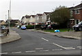
9
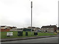
Telecoms mast and cabinets, Llangewydd Road, Bridgend
Near the Bright Hill junction (ahead).
Image: © Jaggery
Taken: 16 Nov 2018
0.06 miles
10
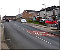
SLOW/ARAF on Barnes Avenue, Bridgend
The English/Welsh text is on the surface of Barnes Avenue.
Image: © Jaggery
Taken: 21 Nov 2018
0.06 miles