IMAGES TAKEN NEAR TO
Ffordd Yr Afon, BRIDGEND, CF31 4UB
Introduction
This page details the photographs taken nearby to Ffordd Yr Afon, CF31 4UB by members of the Geograph project.
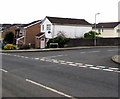
The Geograph project started in 2005 with the aim of publishing, organising and preserving representative images for every square kilometre of Great Britain, Ireland and the Isle of Man.

There are currently over 7.5m images from over14,400 individuals and you can help contribute to the project by visiting https://www.geograph.org.uk
Image Map
Images are licensed for reuse under creativecommons.org/licenses/by-sa/2.0
Notes
- Clicking on the map will re-center to the selected point.
- The higher the marker number, the further away the image location is from the centre of the postcode.
Image Listing (105 Images Found)
Images are licensed for reuse under creativecommons.org/licenses/by-sa/2.0
Image
Details
Distance
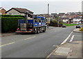
1
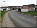
Ffordd yr Afon, Bridgend
Cul-de-sac on the west side of Barnes Avenue.
Image: © Jaggery
Taken: 21 Nov 2018
0.01 miles
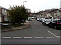
2
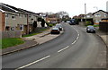
Junction of Ffordd yr Afon and Barnes Avenue, Bridgend
From the right, Ffordd yr Afon joins Barnes Avenue.
Image: © Jaggery
Taken: 21 Nov 2018
0.04 miles
3
Royal Mail drop box, Barnes Avenue, Bridgend
Image: © Jaggery
Taken: 21 Nov 2018
0.04 miles
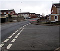
4
Bend in Barnes Avenue, Bridgend
The Heol yr Enfys junction https://www.geograph.org.uk/photo/5983149 is ahead on the left.
Image: © Jaggery
Taken: 21 Nov 2018
0.04 miles
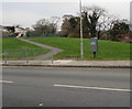
5
Up Barnes Avenue, Bridgend
Barnes Avenue ascends to the northwest past the Lôn y Coed junction on the right.
Image: © Jaggery
Taken: 21 Nov 2018
0.04 miles
6
Heol-y-dail Bridgend
Cul-de-sac on the west side of Barnes Avenue.
Image: © Jaggery
Taken: 21 Nov 2018
0.04 miles
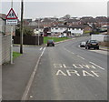
7
SLOW/ARAF on Barnes Avenue, Bridgend
The English/Welsh text is on the surface of Barnes Avenue.
Image: © Jaggery
Taken: 21 Nov 2018
0.05 miles
8
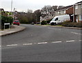
Junction of Barnes Avenue and Heol-y-dail, Bridgend
From the right, Heol-y-dail joins Barnes Avenue.
Image: © Jaggery
Taken: 21 Nov 2018
0.05 miles
9
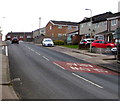
Warning sign - playground, Barnes Avenue, Bridgend
On the approach to this https://www.geograph.org.uk/photo/5983135 play area. The sign text is also in Welsh.
Image: © Jaggery
Taken: 21 Nov 2018
0.05 miles