IMAGES TAKEN NEAR TO
Coed Caer Odin, BRIDGEND, CF31 4TN
Introduction
This page details the photographs taken nearby to Coed Caer Odin, CF31 4TN by members of the Geograph project.
The Geograph project started in 2005 with the aim of publishing, organising and preserving representative images for every square kilometre of Great Britain, Ireland and the Isle of Man.

There are currently over 7.5m images from over14,400 individuals and you can help contribute to the project by visiting https://www.geograph.org.uk
Image Map
Images are licensed for reuse under creativecommons.org/licenses/by-sa/2.0
Notes
- Clicking on the map will re-center to the selected point.
- The higher the marker number, the further away the image location is from the centre of the postcode.
Image Listing (46 Images Found)
Images are licensed for reuse under creativecommons.org/licenses/by-sa/2.0
Image
Details
Distance
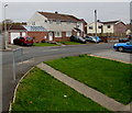
1
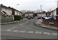
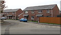
Coed Cae'r Odin, Bridgend
Cul-de-sac on the northwest side of Barnes Avenue.
Image: © Jaggery
Taken: 21 Nov 2018
0.03 miles
2
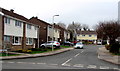
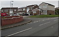
Meini Tirion, Bridgend
Meini Tirion is a cul-de-sac on the north side of Barnes Avenue.
Image: © Jaggery
Taken: 21 Nov 2018
0.03 miles
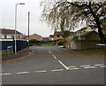
3
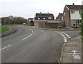
Bend in Barnes Avenue, Bridgend
Looking to the southwest past the Meini Tirion junction https://www.geograph.org.uk/photo/5984829
Image: © Jaggery
Taken: 21 Nov 2018
0.03 miles
4
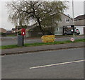
Queen Elizabeth II postbox and a Royal Mail drop box in suburban Bridgend
On the grass strip between the roads named Barnes Avenue and Bedw Arian.
Image: © Jaggery
Taken: 21 Nov 2018
0.04 miles
5
North side of Ffornwg Brook, Bridgend
Houses in the cul-de-sac Ffornwg Brook (Nant Ffornwg in Welsh).
Image: © Jaggery
Taken: 21 Nov 2018
0.07 miles
6
Heol Ty Cribwr, Bridgend
Heol Ty Cribwr is a cul-de-sac on the south side of the road named Bedw Arian.
Image: © Jaggery
Taken: 21 Nov 2018
0.07 miles
7
Ffornwg Brook houses in Bridgend
The cul-de-sac Ffornwg Brook is Nant Ffornwg in Welsh.
Image: © Jaggery
Taken: 21 Nov 2018
0.07 miles
8
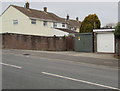
Western Power Distribution electricity substation, Barnes Avenue, Bridgend
The identifier S/S 564025 is on the electricity substation cabinet alongside a lockup garage.
Image: © Jaggery
Taken: 21 Nov 2018
0.07 miles
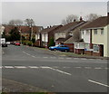
9
Heol Ty Maen houses, Bridgend
Viewed from Barnes Avenue. Heol Ty Maen leads to Maes Gwair.
Image: © Jaggery
Taken: 21 Nov 2018
0.08 miles
10
Heol Fechan houses, Bridgend
Houses in the cul-de-sac Heol Fechan viewed across Barnes Avenue.
A red Parcelforce Worldwide van is on the left.
Image: © Jaggery
Taken: 21 Nov 2018
0.08 miles