IMAGES TAKEN NEAR TO
Parcau Road, BRIDGEND, CF31 4TA
Introduction
This page details the photographs taken nearby to Parcau Road, CF31 4TA by members of the Geograph project.
The Geograph project started in 2005 with the aim of publishing, organising and preserving representative images for every square kilometre of Great Britain, Ireland and the Isle of Man.

There are currently over 7.5m images from over14,400 individuals and you can help contribute to the project by visiting https://www.geograph.org.uk
Image Map
Images are licensed for reuse under creativecommons.org/licenses/by-sa/2.0
Notes
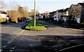
- Clicking on the map will re-center to the selected point.
- The higher the marker number, the further away the image location is from the centre of the postcode.
Image Listing (37 Images Found)
Images are licensed for reuse under creativecommons.org/licenses/by-sa/2.0
Image
Details
Distance
1
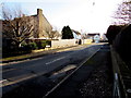
Bryntirion Close, Bridgend
Cul-de-sac on the south side of the A473 Bryntirion Hill.
Image: © Jaggery
Taken: 24 Dec 2014
0.06 miles
2
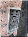
Ordnance Survey Flush Bracket
This OS Flush Bracket can be found on No33 Bryntirion Hill. It marks a point 42.730m above mean sea level.
Image: © Adrian Dust
Taken: 9 Mar 2016
0.06 miles
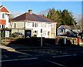
3
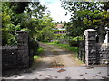
Entrance to Leckwith Cottage, Bryntirion Hill, Bridgend
A rather unconvincing name for the fairly substantial house visible within!
Image: © John Lord
Taken: 26 May 2011
0.08 miles
4
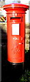
King George VI postbox, Bryntirion Hill, Bridgend
On the right here. http://www.geograph.org.uk/photo/4293259
Image: © Jaggery
Taken: 24 Dec 2014
0.08 miles
5
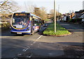
X4 for Neath in the west of Bridgend
Showing First fleet number 63082, a bus on route X4 to Neath heads west on the A473 Bryntirion Hill.
Image: © Jaggery
Taken: 24 Dec 2014
0.08 miles
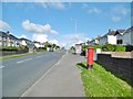
6
Bryntirion Hill bus stop, shelter and postbox in Bridgend
Viewed across the A473 Bryntirion Hill in the west of the town of Bridgend,
on Christmas Eve 2014, a day of bright sunshine and deep shadows.
The red postbox http://www.geograph.org.uk/photo/4293263 on the right is from the reign of King George VI.
Image: © Jaggery
Taken: 24 Dec 2014
0.09 miles
7
Bridgend, postbox
On Bryntirion Hill; ID CF31 97D.
Image: © Mike Faherty
Taken: 13 Jul 2016
0.09 miles
8
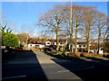
Leckwith Court, Bridgend
Small area of housing on the north side of the A473 Bryntirion Hill.
Image: © Jaggery
Taken: 24 Dec 2014
0.11 miles
9
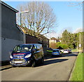
Vehicles parked in Philip Avenue, Bridgend
Looking north from the corner of the A473 Bryntirion Hill.
Nearest the camera is an Ian Morgan (plumbing & heating) van.
Image: © Jaggery
Taken: 24 Dec 2014
0.12 miles
10
Long thin strip of grass alongside the A473 Bryntirion Hill in Bridgend
Viewed from the corner of Bryntirion Close. The grass strip separates houses
(on the south side of the A473) from the main road. An X4 bus http://www.geograph.org.uk/photo/4293290 for Neath is approaching.
Image: © Jaggery
Taken: 24 Dec 2014
0.12 miles