IMAGES TAKEN NEAR TO
Leckwith Court, BRIDGEND, CF31 4LR
Introduction
This page details the photographs taken nearby to Leckwith Court, CF31 4LR by members of the Geograph project.
The Geograph project started in 2005 with the aim of publishing, organising and preserving representative images for every square kilometre of Great Britain, Ireland and the Isle of Man.

There are currently over 7.5m images from over14,400 individuals and you can help contribute to the project by visiting https://www.geograph.org.uk
Image Map
Images are licensed for reuse under creativecommons.org/licenses/by-sa/2.0
Notes
- Clicking on the map will re-center to the selected point.
- The higher the marker number, the further away the image location is from the centre of the postcode.
Image Listing (44 Images Found)
Images are licensed for reuse under creativecommons.org/licenses/by-sa/2.0
Image
Details
Distance
1
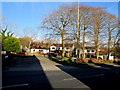
Leckwith Court, Bridgend
Small area of housing on the north side of the A473 Bryntirion Hill.
Image: © Jaggery
Taken: 24 Dec 2014
0.00 miles
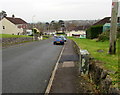
2
Dead-end side arm of Heol-y-frenhines, Bridgend
On the west side of the main route of Heol-y-frenhines.
Image: © Jaggery
Taken: 16 Nov 2018
0.03 miles
3
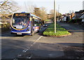
X4 for Neath in the west of Bridgend
Showing First fleet number 63082, a bus on route X4 to Neath heads west on the A473 Bryntirion Hill.
Image: © Jaggery
Taken: 24 Dec 2014
0.04 miles
4
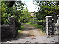
Entrance to Leckwith Cottage, Bryntirion Hill, Bridgend
A rather unconvincing name for the fairly substantial house visible within!
Image: © John Lord
Taken: 26 May 2011
0.04 miles
5
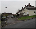
Down Heol-y-frenhines, Bridgend
Heol-y-frenhines (Queen's Road in English) https://www.geograph.org.uk/photo/5984330 descends towards Heol-y-nant which leads to the A473 Park Street.
Image: © Jaggery
Taken: 16 Nov 2018
0.06 miles
6
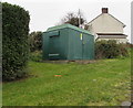
West House electricity substation, Bridgend
The green cabinet set back from the west of Heol-y-frenhines is a Western Power Distribution electricity substation. Its identifier is West House Bridgend 56-4011
Image: © Jaggery
Taken: 16 Nov 2018
0.06 miles
7
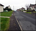
Up Heol-y-frenhines, Bridgend
This part of Heol-y-frenhines is between the Sunny Hill junction and the Elizabeth Road junction (ahead).
Image: © Jaggery
Taken: 16 Nov 2018
0.06 miles
8
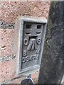
Ordnance Survey Flush Bracket
This OS Flush Bracket can be found on No33 Bryntirion Hill. It marks a point 42.730m above mean sea level.
Image: © Adrian Dust
Taken: 9 Mar 2016
0.06 miles
9
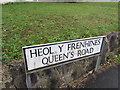
Queen's Road bilingual name sign, Bridgend
Queen's Road is Heol y Frenhines (or Heol-y-frenhines) in Welsh.
Image: © Jaggery
Taken: 16 Nov 2018
0.06 miles
10
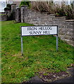
Fron Heulog/Sunny Hill name sign, Bridgend
The Welsh/English sign is on the left here. https://www.geograph.org.uk/photo/5976681
Image: © Jaggery
Taken: 16 Nov 2018
0.07 miles