IMAGES TAKEN NEAR TO
Pen-y-Fai, BRIDGEND, CF31 4LN
Introduction
This page details the photographs taken nearby to CF31 4LN by members of the Geograph project.
The Geograph project started in 2005 with the aim of publishing, organising and preserving representative images for every square kilometre of Great Britain, Ireland and the Isle of Man.

There are currently over 7.5m images from over14,400 individuals and you can help contribute to the project by visiting https://www.geograph.org.uk
Image Map
Images are licensed for reuse under creativecommons.org/licenses/by-sa/2.0
Notes
- Clicking on the map will re-center to the selected point.
- The higher the marker number, the further away the image location is from the centre of the postcode.
Image Listing (51 Images Found)
Images are licensed for reuse under creativecommons.org/licenses/by-sa/2.0
Image
Details
Distance
1
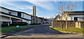
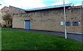
Vaccination Centre for COVID boosters
This entrance to Glanrhyd Hospital is in use for Winter 2022 COVID boosters.
Image: © Steve Barnes
Taken: 19 Nov 2022
0.01 miles
2
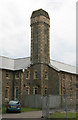
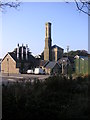
Chimney Glanrhyd Hospital
There are three of these on site. The most substantial is in the midst of demolition but appears likely to be retained. This is one of two on the main surviving block of the hospital. I presume it's a chimney or perhaps made to look like one.
Image: © Chris Allen
Taken: 8 Jun 2009
0.02 miles
4
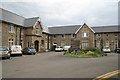
Angelton Clinic, Glanrhyd Hospital, Bridgend
Opened in January 2011, Angelton Clinic is a 42 bed mental health facility providing modern accommodation for older people with a mental health diagnosis. Each patient has their own en-suite bedroom, personalised with their own belongings, making it feel as much like home as possible. It also provides them with their own area where they can have time to themselves or with visitors.
Image: © Jaggery
Taken: 10 Oct 2014
0.03 miles
5
Glanrhyd Hospital
Formerly known as the Angleton Asylum
Image: © John Finch
Taken: 12 Oct 2008
0.03 miles
6
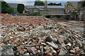
A sea of broken bricks
Demolition at Glanrhyd Hospital. How I wish I had been here a couple of weeks earlier. Very nice buildings.
Image: © Chris Allen
Taken: 8 Jun 2009
0.05 miles
7
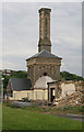
Demolition Glanrhyd Hospital
The Royal College of Pathologists asked me to represent them on an interview panel in Bridgend and I found myself in this excellent old mental hospital that was being part demolished. Luckily I had a camera. This chimney and associated building stands amidst much devastation. I think this is being retained and appears to contain live plant.
Image: © Chris Allen
Taken: 8 Jun 2009
0.06 miles
8
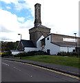
Old chimney stack among new buildings at Glanrhyd Hospital, Bridgend
Viewed in October 2014. http://www.geograph.org.uk/photo/1345416 to a June 2009 view, before the new buildings were erected.
Image: © Jaggery
Taken: 10 Oct 2014
0.06 miles
9
Glanrhyd Hospital electricity substation, Bridgend
The Western Power Distribution electricity substation identifier is GLANRHYD SECURE UNIT S/S 564369.
Image: © Jaggery
Taken: 10 Oct 2014
0.08 miles
10
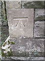
Ordnance Survey Cut Mark
This OS cut mark can be found on the east face of the chapel. It marks a point 30.684m above mean sea level.
Image: © Adrian Dust
Taken: 9 Mar 2016
0.08 miles