IMAGES TAKEN NEAR TO
Tondu Road, BRIDGEND, CF31 4LJ
Introduction
This page details the photographs taken nearby to Tondu Road, CF31 4LJ by members of the Geograph project.
The Geograph project started in 2005 with the aim of publishing, organising and preserving representative images for every square kilometre of Great Britain, Ireland and the Isle of Man.

There are currently over 7.5m images from over14,400 individuals and you can help contribute to the project by visiting https://www.geograph.org.uk
Image Map
Images are licensed for reuse under creativecommons.org/licenses/by-sa/2.0
Notes
- Clicking on the map will re-center to the selected point.
- The higher the marker number, the further away the image location is from the centre of the postcode.
Image Listing (36 Images Found)
Images are licensed for reuse under creativecommons.org/licenses/by-sa/2.0
Image
Details
Distance
1

The A4063 in Bridgend
A quiet moment on the A road which runs northwards to Maesteg and Cymmer from Bridgend. The stretch of the A road within the town of Bridgend is called Tondu Road.
Image: © eswales
Taken: 1 Nov 2022
0.02 miles
2
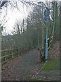
Path to Trews Field Industrial Estate on National Cycle Network Route 885
The image shows the northern half of a short (c. 80 metres) path in Bridgend which lies on Route 885 of the National Cycle Network. The path runs to Trews Field Industrial Estate from a spot on a seemingly unnamed road between the western end of the footbridge over the River Ogmore at Wildmill and the A4063.
The picture shows a bit more of the path than the already uploaded Image
Image: © eswales
Taken: 1 Jan 2023
0.05 miles
3
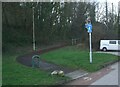
National Cycle Network Route 885 leaving Trews Field Industrial Estate
Having passed along much of the Bridgend industrial estate by road, those travelling northwards on Cycle Route 885 leave it via this path.
Much of the rest of the short path is seen in Image
Image: © eswales
Taken: 1 Jan 2023
0.06 miles
4
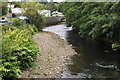
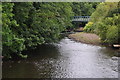
Bridgend : River Ogmore
The River Ogmore heading through Bridgend as seen from the footbridge across it.
Image: © Lewis Clarke
Taken: 24 Aug 2014
0.08 miles
5
Bridgend : River Ogmore
The River Ogmore heading through Bridgend.
Image: © Lewis Clarke
Taken: 24 Aug 2014
0.08 miles
6
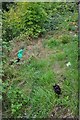
Bridgend : Grassy Riverside
Looking down to the riverside of the Ogmore which seems to be where all the cats hang out.
Image: © Lewis Clarke
Taken: 24 Aug 2014
0.08 miles
7
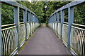
Bridgend : Footbridge
A footbridge across the River Ogmore.
Image: © Lewis Clarke
Taken: 24 Aug 2014
0.08 miles
8
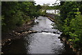
Bridgend : River Ogmore
The River Ogmore heading through the Wild Mill area of Bridgend.
Image: © Lewis Clarke
Taken: 24 Aug 2014
0.10 miles
9
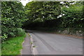
Bridgend : Old Tondu Road
Old Tondu Road heading towards Tondu Road.
Image: © Lewis Clarke
Taken: 24 Aug 2014
0.10 miles
10

Bridgend : Trem Y Brym
A road heading through the residential area of Wild Mill.
Image: © Lewis Clarke
Taken: 24 Aug 2014
0.12 miles