IMAGES TAKEN NEAR TO
Millfield, BRIDGEND, CF31 4JG
Introduction
This page details the photographs taken nearby to Millfield, CF31 4JG by members of the Geograph project.
The Geograph project started in 2005 with the aim of publishing, organising and preserving representative images for every square kilometre of Great Britain, Ireland and the Isle of Man.

There are currently over 7.5m images from over14,400 individuals and you can help contribute to the project by visiting https://www.geograph.org.uk
Image Map
Images are licensed for reuse under creativecommons.org/licenses/by-sa/2.0
Notes
- Clicking on the map will re-center to the selected point.
- The higher the marker number, the further away the image location is from the centre of the postcode.
Image Listing (65 Images Found)
Images are licensed for reuse under creativecommons.org/licenses/by-sa/2.0
Image
Details
Distance
1
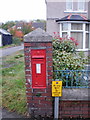
Victorian postbox, Quarella Road, Bridgend
On the east side of Quarella Road, almost opposite The Beeches. http://www.geograph.org.uk/photo/1692094
Image: © Jaggery
Taken: 26 Oct 2009
0.07 miles
2
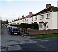
Tynton Road houses, Bridgend
Viewed from Lewis Avenue. Tynton Road is between Tondu Road
and the River Ogmore, near the Brewery Field rugby ground.
Image: © Jaggery
Taken: 24 Dec 2014
0.08 miles
3
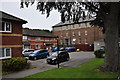
Bridgend : The Beeches
Looking towards parking beside the Beeches off of Quarella Road.
Image: © Lewis Clarke
Taken: 24 Aug 2014
0.08 miles
4
New flats, off Quarella Road, Bridgend
Image: © Alex McGregor
Taken: 17 Jun 2011
0.08 miles
5
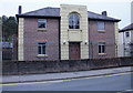
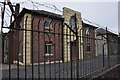
Drill Hall House, Quarella Road, Bridgend
Former military building now a private residence.
Image: © Jaggery
Taken: 26 Oct 2009
0.09 miles
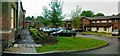
6
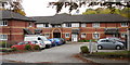
The Beeches, Quarella Road, Bridgend
The Beeches is managed by Wales & West Housing Association. The building contains 44 1-person flats, built in 1989. There are part-time non-resident management staff and a community alarm service.
Image: © Jaggery
Taken: 26 Oct 2009
0.09 miles
7
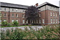
Bridgend : Mental Health Building
A building specialising in the treatment of mental health issues of Quarella Road.
Image: © Lewis Clarke
Taken: 24 Aug 2014
0.10 miles
8
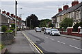
Bridgend : Quarella Road
Looking along Quarella Road and the houses on either side.
Image: © Lewis Clarke
Taken: 24 Aug 2014
0.10 miles
9
Bridgend : Drill Hall
The former military building on Quarella Road which is a now a privately owned building.
Image: © Lewis Clarke
Taken: 24 Aug 2014
0.11 miles
10
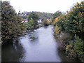
Looking upstream along the River Ogmore, Bridgend
The view upstream from the bridge connecting Quarella Road with Brewery Lane and Tesco's car park. Despite the location near the centre of Bridgend, this view gives the impression of a rural setting, in contrast to the urban view from the other side. http://www.geograph.org.uk/photo/1692133
Image: © Jaggery
Taken: 26 Oct 2009
0.11 miles