IMAGES TAKEN NEAR TO
Coed Parc Court, BRIDGEND, CF31 4HU
Introduction
This page details the photographs taken nearby to Coed Parc Court, CF31 4HU by members of the Geograph project.
The Geograph project started in 2005 with the aim of publishing, organising and preserving representative images for every square kilometre of Great Britain, Ireland and the Isle of Man.

There are currently over 7.5m images from over14,400 individuals and you can help contribute to the project by visiting https://www.geograph.org.uk
Image Map
Images are licensed for reuse under creativecommons.org/licenses/by-sa/2.0
Notes
- Clicking on the map will re-center to the selected point.
- The higher the marker number, the further away the image location is from the centre of the postcode.
Image Listing (441 Images Found)
Images are licensed for reuse under creativecommons.org/licenses/by-sa/2.0
Image
Details
Distance
1
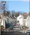
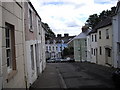
Newcastle Hill, Bridgend
A residential street named Newcastle Hill climbs away from the corner of Park Street and Tondu Road.
Image: © Jaggery
Taken: 12 Feb 2011
0.02 miles
3
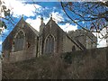
St.Illtyd's Church
Parish church of St.Illtyd, Newcastle, Bridgend.
Image: © Alan Hughes
Taken: 7 Mar 2016
0.04 miles
4
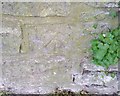
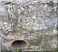
Ordnance Survey Cut Mark
This OS cut mark can be found on the wall of West Cottage, West Road. It marks a point 45.296m above mean sea level.
Image: © Adrian Dust
Taken: 26 May 2018
0.05 miles
5
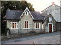
Ty Eglwys,Newcastle Hill
Situated opposite St.Illtyd's church, Ty Eglwys,(Church house), may have been used in the past as a schoolroom for the children of the parish of Newcastle.
Image: © Martin Edwards
Taken: 7 Sep 2007
0.05 miles
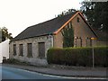
7
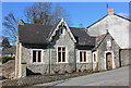
Newcastle Hill
Old building on Newcastle Hill.
Image: © Wayland Smith
Taken: 6 Apr 2013
0.05 miles
8
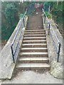
Footsteps to Newcastle Hill
Footsteps to Newcastle Hill, Bridgend.
Image: © Alan Hughes
Taken: 7 Mar 2016
0.06 miles
9
Ordnance Survey Cut Mark
This OS cut mark can be found on the wall of No19 Newcastle Hill. It marks a point 27.615m above mean sea level.
Image: © Adrian Dust
Taken: 26 May 2018
0.06 miles
10
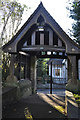
Lych gate at St Illtyd's church, Newcastle - Bridgend
A Grade II* listed structure donated in 1910 by Samuel Llewellyn of Coed Parc. As seen from the path inside the churchyard.
Image: © Mick Lobb
Taken: 17 Dec 2009
0.07 miles