1
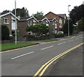
Glan-y-parc houses, Bridgend
Houses on the west side of the road named Glan-y-parc are between Park Court Road and Parkfields Road.
Image: © Jaggery
Taken: 29 May 2017
0.01 miles
2
Glan-y-parc, Bridgend
Houses on the west side of the road, viewed from the corner of Parkfields Road.
The east side of Glan-y-parc is the perimeter of a site occupied by offices.
Image: © Jaggery
Taken: 12 Feb 2011
0.02 miles
3
Sunnyside Offices, Bridgend
Bridgend County Borough Council offices on the west side of Sunnyside Road.
Image: © Jaggery
Taken: 12 Feb 2011
0.04 miles
4
Junction of Park Court Road and Glan-y-parc, Bridgend
The eastern end of Park Court Road viewed across the road named Glan-y-parc.
The speed limit is 20mph ahead.
Image: © Jaggery
Taken: 29 May 2017
0.05 miles
5
Queen Elizabeth II pillarbox, Park Court Road, Bridgend
Located here. http://www.geograph.org.uk/photo/5408184
Image: © Jaggery
Taken: 29 May 2017
0.05 miles
6
Green bench near Bridgend Bowls Centre
A label records that the bench was funded by Bridgend Town Council.
Bridgend Bowls Centre http://www.geograph.org.uk/photo/5408225 is in the background.
Image: © Jaggery
Taken: 29 May 2017
0.06 miles
7
Houses at the eastern end of Park Court Road, Bridgend
Houses on the north side of the road viewed from Angel Street.
Image: © Jaggery
Taken: 29 May 2017
0.06 miles
8
Former Bridgend Magistrates' Court
Viewed across Glan-y-parc in May 2017. In July 2016, the Wales Online website reported that this court had closed its doors for the last time. Earlier in 2016 the UK Government announced its decision to close ten law courts in Wales which were deemed "underused and outdated". Ministers said they wanted to modernise the court system, increasing the use of technology and reserving face-to-face hearings for the most complex and sensitive cases.
Hearings which would have been held here have been transferred to Cardiff and the Vale of Glamorgan Magistrates' Court and Port Talbot Justice Centre.
Image: © Jaggery
Taken: 29 May 2017
0.06 miles
9
Outdated direction sign, Angel Street, Bridgend
The sign pointing to the Magistrates Court remains on the lamppost in May 2017, nearly a year after the Court closed down. http://www.geograph.org.uk/photo/5408133
Image: © Jaggery
Taken: 29 May 2017
0.07 miles
10
Park Street houses in Bridgend
Viewed across Park Street east of the St Leonard's Road junction, west of the Glan-y-Parc junction.
Image: © Jaggery
Taken: 24 Dec 2014
0.07 miles


