IMAGES TAKEN NEAR TO
Angel Street, BRIDGEND, CF31 4AH
Introduction
This page details the photographs taken nearby to Angel Street, CF31 4AH by members of the Geograph project.
The Geograph project started in 2005 with the aim of publishing, organising and preserving representative images for every square kilometre of Great Britain, Ireland and the Isle of Man.

There are currently over 7.5m images from over14,400 individuals and you can help contribute to the project by visiting https://www.geograph.org.uk
Image Map
Images are licensed for reuse under creativecommons.org/licenses/by-sa/2.0
Notes
- Clicking on the map will re-center to the selected point.
- The higher the marker number, the further away the image location is from the centre of the postcode.
Image Listing (304 Images Found)
Images are licensed for reuse under creativecommons.org/licenses/by-sa/2.0
Image
Details
Distance
1
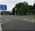
Bilingual cycle lane sign, Angel Street, Bridgend
The English/Welsh sign is in the background here. http://www.geograph.org.uk/photo/5493360
Image: © Jaggery
Taken: 29 May 2017
0.03 miles
2
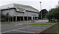
Bridgend Bowls Centre
Set back from the south side of Angel Street, the building is on the east side of two bowling greens.
Image: © Jaggery
Taken: 29 May 2017
0.03 miles
3
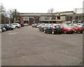
Bridgend Recreation Centre
Located on the south side of Angel Street, alongside the River Ogmore.
Facilities include the area's largest leisure pool, with hydro-slide, wave machine and a Hydrogym.
A 'No Limits' fitness suite has a Technogym and Wellness System, an interactive and motivational tool which stores personalised gym workout programmes, giving feedback and guidance. There are also fitness classes, a sports hall and courts.
Image: © Jaggery
Taken: 12 Feb 2011
0.03 miles
4
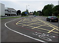
Bend in Angel Street cycle lane, Bridgend
The cycle lane bends around a yellow-marked Keep Clear area.
Image: © Jaggery
Taken: 29 May 2017
0.03 miles
5
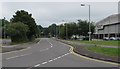
Angel Street towards Bridgend town centre
Bridgend Bowls Centre http://www.geograph.org.uk/photo/5408225 is on the right.
Image: © Jaggery
Taken: 29 May 2017
0.04 miles
6
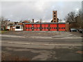
Bridgend Fire Station
Located on the north side of Angel Street, opposite Bridgend Recreation Centre http://www.geograph.org.uk/photo/2275305 and the River Ogmore. Part of South Wales Fire & Rescue Service, the station opened in 1964.
Image: © Jaggery
Taken: 12 Feb 2011
0.04 miles
7
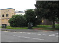
Two telecoms cabinets on a Bridgend corner
The Virgin Media cabinet on the left is alongside Angel Street.
The BT cabinet is near a tree at the southern end of Sunnyside Road.
Image: © Jaggery
Taken: 29 May 2017
0.04 miles
8
Bridgend Bowls Centre
Located on the south side of Angel Street, next door to Bridgend Recreation Centre. http://www.geograph.org.uk/photo/2275305
Image: © Jaggery
Taken: 12 Feb 2011
0.05 miles
9
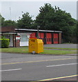
Yellow donations bin outside Bridgend Fire Station
For donations to the Fire Fighters charity.
Image: © Jaggery
Taken: 29 May 2017
0.05 miles
10
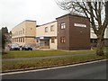
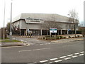
Bridgend Magistrates' Court
Located on the corner of Angel Street and Sunnyside Road.
The former Bridgend Magistrates' Court http://www.geograph.org.uk/photo/1602911 is Grade II listed.
Image: © Jaggery
Taken: 12 Feb 2011
0.06 miles