IMAGES TAKEN NEAR TO
East Street, BRIDGEND, CF31 3DQ
Introduction
This page details the photographs taken nearby to East Street, CF31 3DQ by members of the Geograph project.
The Geograph project started in 2005 with the aim of publishing, organising and preserving representative images for every square kilometre of Great Britain, Ireland and the Isle of Man.

There are currently over 7.5m images from over14,400 individuals and you can help contribute to the project by visiting https://www.geograph.org.uk
Image Map
Images are licensed for reuse under creativecommons.org/licenses/by-sa/2.0
Notes
- Clicking on the map will re-center to the selected point.
- The higher the marker number, the further away the image location is from the centre of the postcode.
Image Listing (57 Images Found)
Images are licensed for reuse under creativecommons.org/licenses/by-sa/2.0
Image
Details
Distance
1
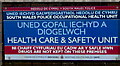
Drugs are not kept on these premises, Coychurch
On the board on the left here. https://www.geograph.org.uk/photo/6687098
Image: © Jaggery
Taken: 23 Nov 2020
0.11 miles
2
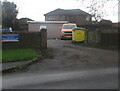
Entrance to the Health Care & Safety Unit, Coychurch
From Hawthorn Drive. Text on the board https://www.geograph.org.uk/photo/6687099 on the left includes
SOUTH WALES POLICE OCCUPATIONAL HEALTH UNIT
HEALTH CARE & SAFETY UNIT
DRUGS ARE NOT KEPT ON THESE PREMISES.
The text is also in Welsh.
Image: © Jaggery
Taken: 23 Nov 2020
0.11 miles
3
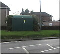
Dark green cabinet, Hawthorn Drive, Coychurch
The cabinet is a Western Power Distribution electricity substation.
Its identifier is NEW BRYNFFRWD S/S 56-1268.
Image: © Jaggery
Taken: 23 Nov 2020
0.11 miles
4
Weight limit sign, Hawthorn Drive, Coychurch
No vehicles heavier than 7.5 tonnes except for loading.
Image: © Jaggery
Taken: 23 Nov 2020
0.12 miles
5
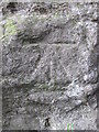
Ordnance Survey Cut Mark
This OS cut mark can be found on the NW buttress of the railway bridge. It marks a point 23.936m above mean sea level.
Image: © Adrian Dust
Taken: 4 May 2015
0.12 miles
6
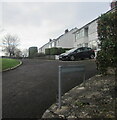
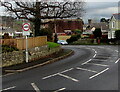
Houses above Hawthorn Drive, Coychurch
Alongside a dead-end side road.
Image: © Jaggery
Taken: 23 Nov 2020
0.13 miles
7
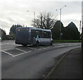
Bus on Route 64 to Bridgend in Coychurch
The First South & West Wales bus is on Route 64 from Talbot Green to Bridgend bus station in November 2020.
Image: © Jaggery
Taken: 23 Nov 2020
0.13 miles
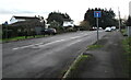
8
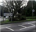
Direction and distances sign in Coychurch
2½ miles from Bridgend, 1¾ miles from Coity.
Image: © Jaggery
Taken: 23 Nov 2020
0.13 miles
9
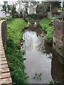
Nant Bryn Glas
Nant Bryn Glas - a stream flowing through Coychurch.
Image: © Alan Hughes
Taken: 15 Apr 2016
0.14 miles
10
Waterton Road, Coychurch
The dead-end southern part of Waterton Road viewed from the Treoes Road junction.
Image: © Jaggery
Taken: 23 Nov 2020
0.14 miles