IMAGES TAKEN NEAR TO
Cowbridge Road, BRIDGEND, CF31 3BY
Introduction
This page details the photographs taken nearby to Cowbridge Road, CF31 3BY by members of the Geograph project.
The Geograph project started in 2005 with the aim of publishing, organising and preserving representative images for every square kilometre of Great Britain, Ireland and the Isle of Man.

There are currently over 7.5m images from over14,400 individuals and you can help contribute to the project by visiting https://www.geograph.org.uk
Image Map
Images are licensed for reuse under creativecommons.org/licenses/by-sa/2.0
Notes
- Clicking on the map will re-center to the selected point.
- The higher the marker number, the further away the image location is from the centre of the postcode.
Image Listing (342 Images Found)
Images are licensed for reuse under creativecommons.org/licenses/by-sa/2.0
Image
Details
Distance
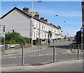
1
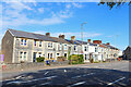
Cowbridge Road
Terraced houses in Bridgend.
Image: © Wayland Smith
Taken: 2 May 2021
0.01 miles
2
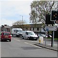
Direction and distances sign, Cowbridge Road, Bridgend
In the middle of the A473 Cowbridge Road 4 miles from the M4 motorway, 11 miles from Llantrisant.
Image: © Jaggery
Taken: 18 Apr 2017
0.02 miles
3
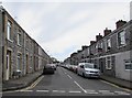
Cheltenham Terrace, Bridgend
From Free School Court along Cheltenham Terrace towards Suffolk Street.
Image: © Jaggery
Taken: 18 Apr 2017
0.02 miles
4
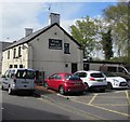
East side of the Five Bells pub, Bridgend
The Five Bells Road side of the pub on the corner of Ewenny Road.
Image: © Jaggery
Taken: 18 Apr 2017
0.03 miles
5
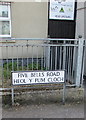
Five Bells Road/Heol y Pum Cloch name sign, Bridgend
The English/Welsh road name sign is near Cabo Roche bar. http://www.geograph.org.uk/photo/5384855
Image: © Jaggery
Taken: 18 Apr 2017
0.03 miles
6
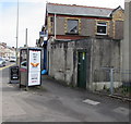
Five Bells electricity substation, Bridgend
A padlocked dark green door is at the entrance to the Western Power Distribution electricity substation on the corner of Five Bells Road and Cowbridge Road. The substation identifier is FIVE BELLS 56-4249.
Image: © Jaggery
Taken: 18 Apr 2017
0.03 miles
7
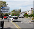
Directions sign facing Cowbridge Road, Bridgend
Facing the A473 Cowbridge Road on the approach to the town centre.
Image: © Jaggery
Taken: 18 Apr 2017
0.03 miles
8
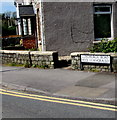
Bilingual street name sign on a Bridgend corner
The sign facing Cowbridge Road shows that Coychurch Road is Heol Llangrallo in Welsh.
Image: © Jaggery
Taken: 18 Apr 2017
0.03 miles
9
Junction of Cowbridge Road and Coychurch Road, Bridgend
The blue and white signs show that Coychurch Road is a one-way road.
Image: © Jaggery
Taken: 18 Apr 2017
0.03 miles
10
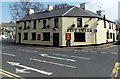
The Five Bells, Bridgend
Pub on the corner of Ewenny Road and Five Bells Road.
Image: © Jaggery
Taken: 30 Mar 2014
0.03 miles