IMAGES TAKEN NEAR TO
St. James Park, BRIDGEND, CF31 2NP
Introduction
This page details the photographs taken nearby to St. James Park, CF31 2NP by members of the Geograph project.
The Geograph project started in 2005 with the aim of publishing, organising and preserving representative images for every square kilometre of Great Britain, Ireland and the Isle of Man.

There are currently over 7.5m images from over14,400 individuals and you can help contribute to the project by visiting https://www.geograph.org.uk
Image Map
Images are licensed for reuse under creativecommons.org/licenses/by-sa/2.0
Notes
- Clicking on the map will re-center to the selected point.
- The higher the marker number, the further away the image location is from the centre of the postcode.
Image Listing (11 Images Found)
Images are licensed for reuse under creativecommons.org/licenses/by-sa/2.0
Image
Details
Distance
1
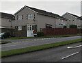
Junction of Brackla Way and Hawthorn Way, Brackla, Bridgend
Viewed across Brackla Way. Hawthorn Way leads to Maple Drive.
Image: © Jaggery
Taken: 23 Nov 2020
0.17 miles
2

Dark green cabinet, Brackla Way, Brackla, Bridgend
The dark green telecoms cabinet is located near the Hawthorn Way junction.
Image: © Jaggery
Taken: 23 Nov 2020
0.17 miles
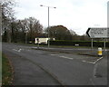
3

Bus stop and shelter, Brackla Way, Brackla, Bridgend
This stop at the eastern edge of Brackla is for buses to Bridgend town centre and bus station.
Image: © Jaggery
Taken: 23 Nov 2020
0.19 miles
4
From 30 to 40, Brackla Way, Brackla, Bridgend
At the eastern edge of Brackla, the 30mph speed limit increases to 40mph.
Image: © Jaggery
Taken: 23 Nov 2020
0.20 miles
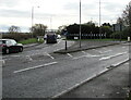
5
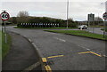
Roundabout near Coychurch Crematorium
Turn left at the roundabout for Coychurch Crematorium.
Image: © Jaggery
Taken: 23 Nov 2020
0.21 miles
6
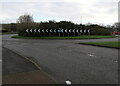
Brackla Roundabout
The building behind the roundabout is the Crematorium
Image: © kenneth rees
Taken: 14 Feb 2007
0.22 miles
7
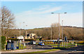
Approach to Brackla Roundabout, Bridgend
Looking to the SSE along Simonston Road.
Image: © Jaggery
Taken: 23 Nov 2020
0.23 miles
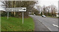
8
Coychurch Crematorium direction sign
The black arrow on the sign points along Simonston Road towards the crematorium site entrance on the left. Simonston Road also leads to Brackla Industrial Estate and Coity. The sign text is also in Welsh.
Image: © Jaggery
Taken: 23 Nov 2020
0.23 miles
9
Bilingual Coychurch Crematorium direction sign
The sign alongside Simonston Road shows that Coychurch Crematorium is Amlosgfa Llangrallo in Welsh.
Image: © Jaggery
Taken: 23 Nov 2020
0.24 miles
10
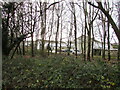
Fox Hollows houses behind trees, Brackla, Bridgend
Viewed from Simonston Road.
Image: © Jaggery
Taken: 23 Nov 2020
0.24 miles