IMAGES TAKEN NEAR TO
Princess Way, BRIDGEND, CF31 2LN
Introduction
This page details the photographs taken nearby to Princess Way, CF31 2LN by members of the Geograph project.
The Geograph project started in 2005 with the aim of publishing, organising and preserving representative images for every square kilometre of Great Britain, Ireland and the Isle of Man.

There are currently over 7.5m images from over14,400 individuals and you can help contribute to the project by visiting https://www.geograph.org.uk
Image Map
Images are licensed for reuse under creativecommons.org/licenses/by-sa/2.0
Notes
- Clicking on the map will re-center to the selected point.
- The higher the marker number, the further away the image location is from the centre of the postcode.
Image Listing (4 Images Found)
Images are licensed for reuse under creativecommons.org/licenses/by-sa/2.0
Image
Details
Distance
1
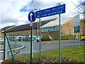
Ysgol Bro Ogwr
Welsh-medium school - Ysgol Bro Ogwr, Brdgend.
Image: © Alan Hughes
Taken: 7 Mar 2016
0.01 miles
4
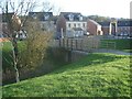
Cycle and pedestrian bridge by Ffordd Cadfan, Bridgend
The bridge carries a path for cyclists and pedestrians over a stream. The latter can be seen in Image
Image: © eswales
Taken: 28 Nov 2022
0.24 miles