IMAGES TAKEN NEAR TO
Traws Fynydd, BRIDGEND, CF31 2HR
Introduction
This page details the photographs taken nearby to Traws Fynydd, CF31 2HR by members of the Geograph project.
The Geograph project started in 2005 with the aim of publishing, organising and preserving representative images for every square kilometre of Great Britain, Ireland and the Isle of Man.

There are currently over 7.5m images from over14,400 individuals and you can help contribute to the project by visiting https://www.geograph.org.uk
Image Map
Images are licensed for reuse under creativecommons.org/licenses/by-sa/2.0
Notes
- Clicking on the map will re-center to the selected point.
- The higher the marker number, the further away the image location is from the centre of the postcode.
Image Listing (7 Images Found)
Images are licensed for reuse under creativecommons.org/licenses/by-sa/2.0
Image
Details
Distance
1
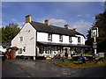
The Haywain, Coychurch Rd, Tremains, Bridgend
Image: © John Lord
Taken: 23 Oct 2010
0.02 miles
2
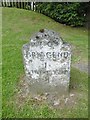
Old Milestone by the B4181, Coychurch Road, Brackla Parish
By the B4181, in parish of Brackla (Bridgend County Borough District), Coychurch Road, next to Haywain PH on grass verge.
Inscription reads:- : TO / BRIDGEND / 1 / LLANTRISANT / 10 :
Surveyed
Milestone Society National ID: GLA_BELT01
Image: © Milestone Society
Taken: Unknown
0.05 miles
3
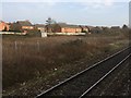
View from a Cardiff-Swansea train - edge of Brackla housing development
Image: © Nigel Thompson
Taken: 27 Jan 2017
0.13 miles

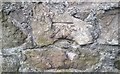
5
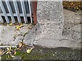
Ordnance Survey Cut Mark
This OS cut mark can be found on the concrete wall north side of North Road. It marks a point 25.942m above mean sea level.
Image: © Adrian Dust
Taken: 22 Oct 2022
0.16 miles
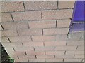
6
Ordnance Survey Cut Mark
This OS cut mark can be found on the barn of No62 Coybridge Road. It marks a point 34.162m above mean sea level.
Image: © Adrian Dust
Taken: 26 May 2018
0.17 miles
7
Ordnance Survey Cut Mark
This OS cut mark can be found on No15 The Triangle. It marks a point 55.822m above mean sea level.
Image: © Adrian Dust
Taken: 22 Oct 2022
0.19 miles