IMAGES TAKEN NEAR TO
Napier Close, BRIDGEND, CF31 1TW
Introduction
This page details the photographs taken nearby to Napier Close, CF31 1TW by members of the Geograph project.
The Geograph project started in 2005 with the aim of publishing, organising and preserving representative images for every square kilometre of Great Britain, Ireland and the Isle of Man.

There are currently over 7.5m images from over14,400 individuals and you can help contribute to the project by visiting https://www.geograph.org.uk
Image Map
Images are licensed for reuse under creativecommons.org/licenses/by-sa/2.0
Notes
- Clicking on the map will re-center to the selected point.
- The higher the marker number, the further away the image location is from the centre of the postcode.
Image Listing (174 Images Found)
Images are licensed for reuse under creativecommons.org/licenses/by-sa/2.0
Image
Details
Distance
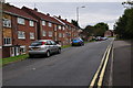
1
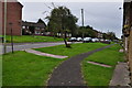
Bridgend : High View
A residential road in Bridgend.
Image: © Lewis Clarke
Taken: 24 Aug 2014
0.06 miles
2
Bridgend : Herbert Street
Herbert Street seen from the junction at Acland Road.
Image: © Lewis Clarke
Taken: 24 Aug 2014
0.08 miles
3

Bridgend : Footpath
A footpath heading from Waunscil Avenue to Pen-y-banc.
Image: © Lewis Clarke
Taken: 24 Aug 2014
0.08 miles
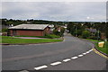
4
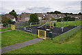
Bridgend : Playground
A playground in the Tremains area of Bridgend.
Image: © Lewis Clarke
Taken: 24 Aug 2014
0.08 miles
5
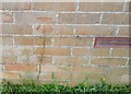
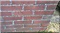
Ordnance Survey Cut Mark
This OS cut mark can be found on No47 Waunscil Avenue. It marks a point 52.810m above mean sea level.
Image: © Adrian Dust
Taken: 26 May 2018
0.10 miles
6
Bridgend : Waunscil Avenue
A small residential lane heading through Bridgend.
Image: © Lewis Clarke
Taken: 24 Aug 2014
0.11 miles
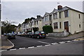
7
Bridgend : Minerva Street
Looking down along Minerva Street from the junction with High View.
Image: © Lewis Clarke
Taken: 24 Aug 2014
0.12 miles
8
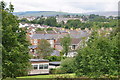
Bridgend : Town Scenery
Looking out across the suburbs of Bridgend.
Image: © Lewis Clarke
Taken: 24 Aug 2014
0.12 miles
9
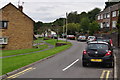
Bridgend : High View
Looking along a small residential road in Bridgend.
Image: © Lewis Clarke
Taken: 24 Aug 2014
0.12 miles
10
Ordnance Survey Cut Mark
This OS cut mark can be found on the Block of Flats, Nos236-246 Waunscil Avenue. It marks a point 42.049m above mean sea level.
Image: © Adrian Dust
Taken: 26 May 2018
0.12 miles