IMAGES TAKEN NEAR TO
Coity Road, BRIDGEND, CF31 1NE
Introduction
This page details the photographs taken nearby to Coity Road, CF31 1NE by members of the Geograph project.
The Geograph project started in 2005 with the aim of publishing, organising and preserving representative images for every square kilometre of Great Britain, Ireland and the Isle of Man.

There are currently over 7.5m images from over14,400 individuals and you can help contribute to the project by visiting https://www.geograph.org.uk
Image Map
Images are licensed for reuse under creativecommons.org/licenses/by-sa/2.0
Notes
- Clicking on the map will re-center to the selected point.
- The higher the marker number, the further away the image location is from the centre of the postcode.
Image Listing (27 Images Found)
Images are licensed for reuse under creativecommons.org/licenses/by-sa/2.0
Image
Details
Distance
1
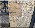
Ordnance Survey Cut Mark
This OS cut mark can be found on No75 Coity Road. It marks a point 36.280m above mean sea level.
Image: © Adrian Dust
Taken: 26 May 2018
0.03 miles
2
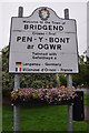
Bridgend : Town Sign
The welcome to Bridgend sign on Coity Road.
Image: © Lewis Clarke
Taken: 24 Aug 2014
0.04 miles
3
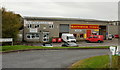
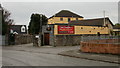
Business premises, Pen-y-Bont Industrial Estate, Bridgend
Located on the west side of Coity Road, opposite Castle View. Premises shown are City Electrical Factors Ltd and Bathwick Tyres.
Image: © Jaggery
Taken: 26 Oct 2009
0.04 miles
4
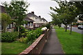
Bridgen : Coity Road Pavement
A pavement beside Coity Road in Bridgend.
Image: © Lewis Clarke
Taken: 24 Aug 2014
0.04 miles
5
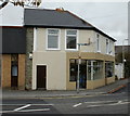
Cavalli's Fish & Chips, Bridgend
63b Coity Road.
Image: © Jaggery
Taken: 26 Oct 2009
0.10 miles
6
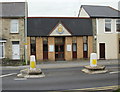
Salvation Army, Coity Road, Bridgend
Bridgend Corps premises, 63 Coity Road.
Image: © Jaggery
Taken: 26 Oct 2009
0.10 miles
7
Caeffatri Inn, Bridgend
The Caeffatri is a 17th century mansion house converted into a public house.
Located on Castle View, close to Coity Road.
Image: © Jaggery
Taken: 26 Oct 2009
0.10 miles
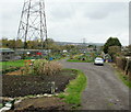
8
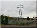
Allotments pylon, Bridgend
A pylon looms over the edge of allotments on the west side of Coity Road, close to the Great Western Avenue junction.
Image: © Jaggery
Taken: 26 Oct 2009
0.10 miles
9
Coity Road allotments, Bridgend
The view from Coity Road westwards.
Image: © Jaggery
Taken: 26 Oct 2009
0.10 miles
10
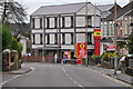
Bridgend : Coity Road B4181
Looking along Coity Road as it heads through Bridgend.
Image: © Lewis Clarke
Taken: 24 Aug 2014
0.12 miles