1
Derwen Road, Bridgend
Derwen Road, Bridgend, former fire station, with crest from King Edward VIII dated 1936
Image: © Colin Prosser
Taken: 3 Jun 2023
0.00 miles
2
Derwen Road, Bridgend
Derwen Road, Bridgend, abandoned Fire Station
Image: © Colin Prosser
Taken: 3 Jun 2023
0.00 miles
3
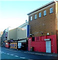
Derelict former Post Office garage, Bridgend
Viewed across Derwen Road. The faded royal monogram http://www.geograph.org.uk/photo/4994092 on the building shows that this is one of very few Crown buildings constructed during the short reign of Edward VIII, the uncrowned king who reigned from January 1936-December 1936.
Image: © Jaggery
Taken: 1 Apr 2016
0.01 miles
4
Derelict former Post Office garage, Bridgend
Viewed across Derwen Road. The faded royal monogram http://www.geograph.org.uk/photo/4994092 on the building shows that this is one of very few Crown buildings constructed during the short reign of Edward VIII, the uncrowned king who reigned from January 1936-December 1936.
Image: © Jaggery
Taken: 30 Jun 2016
0.01 miles
5
Back of the former Bridgend post office
This is the Derwen Road side of the former post office. Its front http://www.geograph.org.uk/photo/1602879 faces Court Road.
Image: © Jaggery
Taken: 7 Dec 2012
0.02 miles
6
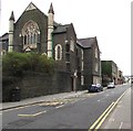
South along Derwen Road, Bridgend
From the corner of Wyndham Street.
Hope Baptist Church http://www.geograph.org.uk/photo/4994333 is on the left.
Sax bar & nightclub http://www.geograph.org.uk/photo/4994073 is in the distance.
Image: © Jaggery
Taken: 1 Apr 2016
0.02 miles
7
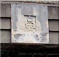
King Edward VIII 1936 monogram, Bridgend
The faded monogram is on this http://www.geograph.org.uk/photo/4994086 derelict former Post Office garage in Derwen Road.
Image: © Jaggery
Taken: 1 Apr 2016
0.02 miles
8
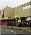
Bowler & Sax Night Club, Bridgend
Located in Derwen Road.
Image: © Jaggery
Taken: 7 Dec 2012
0.02 miles
9
Sax nightclub name sign, Bridgend
Depicting a saxophone, the sign is here. http://www.geograph.org.uk/photo/5020255
Image: © Jaggery
Taken: 30 Jun 2016
0.02 miles
10
Nightclub recruitment banner, Derwen Road, Bridgend
The banner on the wall of Sax Nightclub in November 2020 shows
"NOW RECRUITING STAFF - Bar Staff, Glass Collectors, SIA Doorstaff"
Image: © Jaggery
Taken: 23 Nov 2020
0.02 miles


