IMAGES TAKEN NEAR TO
Springfield Gardens, BRIDGEND, CF31 1HP
Introduction
This page details the photographs taken nearby to Springfield Gardens, CF31 1HP by members of the Geograph project.
The Geograph project started in 2005 with the aim of publishing, organising and preserving representative images for every square kilometre of Great Britain, Ireland and the Isle of Man.

There are currently over 7.5m images from over14,400 individuals and you can help contribute to the project by visiting https://www.geograph.org.uk
Image Map
Images are licensed for reuse under creativecommons.org/licenses/by-sa/2.0
Notes
- Clicking on the map will re-center to the selected point.
- The higher the marker number, the further away the image location is from the centre of the postcode.
Image Listing (19 Images Found)
Images are licensed for reuse under creativecommons.org/licenses/by-sa/2.0
Image
Details
Distance
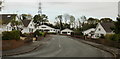
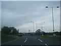
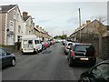
2

Housing on north side of Glynbridge Gardens, Bridgend
Viewed from Coity Road.
Image: © Jaggery
Taken: 26 Oct 2009
0.17 miles
3
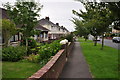
Bridgen : Coity Road Pavement
A pavement beside Coity Road in Bridgend.
Image: © Lewis Clarke
Taken: 24 Aug 2014
0.18 miles
4
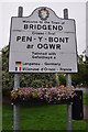
Bridgend : Town Sign
The welcome to Bridgend sign on Coity Road.
Image: © Lewis Clarke
Taken: 24 Aug 2014
0.18 miles
5
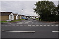
Bridgend : Glynbridge Gardens
Glynbridge Gardens seen at the junction with Coity Road.
Image: © Lewis Clarke
Taken: 24 Aug 2014
0.18 miles
7
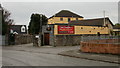
Caeffatri Inn, Bridgend
The Caeffatri is a 17th century mansion house converted into a public house.
Located on Castle View, close to Coity Road.
Image: © Jaggery
Taken: 26 Oct 2009
0.19 miles
8
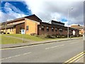
Princess of Wales Hospital, Bridgend
Staff Entrance to Car Park at the Princess of Wales Hospital, Bridgend.
Image: © Alan Hughes
Taken: 7 Mar 2016
0.19 miles
9
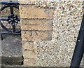
Ordnance Survey Cut Mark
This OS cut mark can be found on No75 Coity Road. It marks a point 36.280m above mean sea level.
Image: © Adrian Dust
Taken: 26 May 2018
0.19 miles
10
Morfa Street, Bridgend
Looking along Morfa Street towards the white houses which line the horseshoe-shaped end of the street.
Image: © Jaggery
Taken: 26 Oct 2009
0.19 miles