IMAGES TAKEN NEAR TO
Green Street, BRIDGEND, CF31 1HF
Introduction
This page details the photographs taken nearby to Green Street, CF31 1HF by members of the Geograph project.
The Geograph project started in 2005 with the aim of publishing, organising and preserving representative images for every square kilometre of Great Britain, Ireland and the Isle of Man.

There are currently over 7.5m images from over14,400 individuals and you can help contribute to the project by visiting https://www.geograph.org.uk
Image Map
Images are licensed for reuse under creativecommons.org/licenses/by-sa/2.0
Notes
- Clicking on the map will re-center to the selected point.
- The higher the marker number, the further away the image location is from the centre of the postcode.
Image Listing (414 Images Found)
Images are licensed for reuse under creativecommons.org/licenses/by-sa/2.0
Image
Details
Distance
1
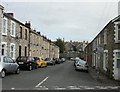
Green Street, Bridgend
Viewed from Meadow Street.
Image: © Jaggery
Taken: 26 Oct 2009
0.03 miles
2
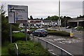
Bridgend : Litchard Hill
Litchard Hill road joins the roundabout.
Image: © Lewis Clarke
Taken: 24 Aug 2014
0.06 miles
3
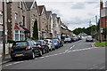
Bridgend : Morfa Street
Looking along Morfa Street in Bridgend.
Image: © Lewis Clarke
Taken: 24 Aug 2014
0.06 miles
4
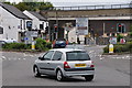
Bridgend : Boulevard de Villenave d'Ormon
The Boulevard de Villenave d'Ormon as seen from the roundabout. Tremains Road heads off to the left.
Image: © Lewis Clarke
Taken: 24 Aug 2014
0.06 miles
5
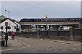
Bridgend : Minerva Street
Looking along Minerva Street. A First Great Western train can be seen on the overpass.
Image: © Lewis Clarke
Taken: 24 Aug 2014
0.07 miles
6
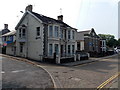
Corner of Minerva Street and Morfa Street, Bridgend
Christchurch Baptist Chapel (or Emmanuel Christchurch) is in Morfa Street on the right. http://www.geograph.org.uk/photo/1603061
Image: © Jaggery
Taken: 6 Sep 2014
0.08 miles
7
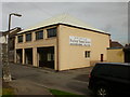
Penybont Chapel of Rest, Bridgend
Penybont Funeral Services chapel of rest, located at the southern end of Meadow Street. Adjacent to their monumental masons premises. http://www.geograph.org.uk/photo/1603139
Image: © Jaggery
Taken: 26 Oct 2009
0.08 miles
8
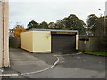
Penybont Monumental Masons Ltd, Bridgend
Premises at the southern end of Meadow Street, adjacent to their chapel of rest.
http://www.geograph.org.uk/photo/1603137
Image: © Jaggery
Taken: 26 Oct 2009
0.08 miles
9
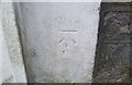
Ordnance Survey Cut Mark
This OS cut mark can be found on No56 Coity Road. It marks a point 30.904m above mean sea level.
Image: © Adrian Dust
Taken: 26 May 2018
0.08 miles
10
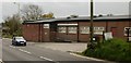
GWR Club, Coity Road, Bridgend
Great Western Railway Staff Association Sports & Social Club.
Image: © Jaggery
Taken: 26 Oct 2009
0.09 miles