IMAGES TAKEN NEAR TO
Lewis Road, CARDIFF, CF24 5ER
Introduction
This page details the photographs taken nearby to Lewis Road, CF24 5ER by members of the Geograph project.
The Geograph project started in 2005 with the aim of publishing, organising and preserving representative images for every square kilometre of Great Britain, Ireland and the Isle of Man.

There are currently over 7.5m images from over14,400 individuals and you can help contribute to the project by visiting https://www.geograph.org.uk
Image Map
Images are licensed for reuse under creativecommons.org/licenses/by-sa/2.0
Notes
- Clicking on the map will re-center to the selected point.
- The higher the marker number, the further away the image location is from the centre of the postcode.
Image Listing (16 Images Found)
Images are licensed for reuse under creativecommons.org/licenses/by-sa/2.0
Image
Details
Distance
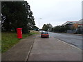
2
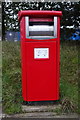
Royal Mail business box on Lewis Road, Cardiff
Postbox No. CF24 200.
See Image] for context.
Image: © JThomas
Taken: 15 Oct 2019
0.06 miles
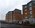
3
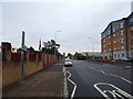
Forgeside Close
Residential Development at Forgeside Close, adjacent to the East Moors Industrial Estate.
Image: © Alan Hughes
Taken: 27 Feb 2017
0.06 miles
4
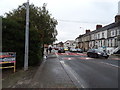
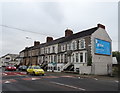
Lewis Road, Cardiff
Showing position of Postbox No. CF24 200.
See Image] for postbox.
Image: © JThomas
Taken: 15 Oct 2019
0.07 miles
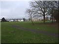
7
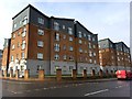
East Moors
Construction work on progress on the East Moors Industrial Estate.
Image: © Alan Hughes
Taken: 27 Feb 2017
0.16 miles
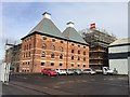
9
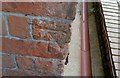
Ordnance Survey Cut Mark
This OS cut mark can be found on the west angle of The Maltings. It marks a point 8.950m above mean sea level.
Image: © Adrian Dust
Taken: 12 Oct 2017
0.19 miles