IMAGES TAKEN NEAR TO
Alfred Street, CARDIFF, CF24 4TY
Introduction
This page details the photographs taken nearby to Alfred Street, CF24 4TY by members of the Geograph project.
The Geograph project started in 2005 with the aim of publishing, organising and preserving representative images for every square kilometre of Great Britain, Ireland and the Isle of Man.

There are currently over 7.5m images from over14,400 individuals and you can help contribute to the project by visiting https://www.geograph.org.uk
Image Map
Images are licensed for reuse under creativecommons.org/licenses/by-sa/2.0
Notes
- Clicking on the map will re-center to the selected point.
- The higher the marker number, the further away the image location is from the centre of the postcode.
Image Listing (92 Images Found)
Images are licensed for reuse under creativecommons.org/licenses/by-sa/2.0
Image
Details
Distance
1
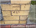
Ordnance Survey Cut Mark
This OS cut mark can be found on No52 Moy Road. It marks a point 15.158m above mean sea level.
Image: © Adrian Dust
Taken: 12 Oct 2017
0.04 miles
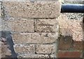
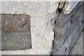
2
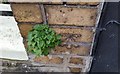
Ordnance Survey Cut Mark
This OS cut mark can be found on the wall post of No39 Angus Street. It marks a point 14.646m above mean sea level.
Image: © Adrian Dust
Taken: 12 Oct 2017
0.04 miles
3
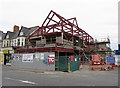
Rebuild on Albany Road
The former AG Meek shoe shop on Albany was recently demolished, and the replacement building is being constructed very quickly!
Image: © Gareth James
Taken: 28 Apr 2013
0.06 miles
4
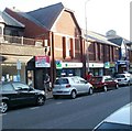
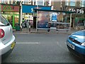
Lloyds TSB Roath Park, Cardiff
Bank branch located at 1-4 The Globe Centre, Wellfield Road.
Image: © Jaggery
Taken: 11 Oct 2010
0.06 miles
5
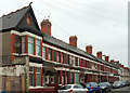
Alfred Street, Roath
Terraced houses on the west side of the street between Moy Road and Dalcross Street.
Image: © Derek Harper
Taken: 16 Jun 2018
0.07 miles
6
Ordnance Survey Cut Mark
This OS cut mark can be found on No50 Donald Street. It marks a point 15.203m above mean sea level.
Image: © Adrian Dust
Taken: 12 Oct 2017
0.07 miles
8
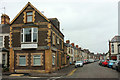
Junction on Angus Street, Roath
The junction with Moy Road.
Image: © Derek Harper
Taken: 16 Jun 2018
0.07 miles
9

Ordnance Survey Cut Mark
This OS cut mark can be found on the inner west angle of the school. It marks a point 13.802m above mean sea level.
Image: © Adrian Dust
Taken: 12 Oct 2017
0.08 miles
10
Ordnance Survey Cut Mark
This damaged OS cut mark can be found on the Methodist Church. It marks a point 13.439m above mean sea level.
Image: © Adrian Dust
Taken: 12 Oct 2017
0.08 miles