IMAGES TAKEN NEAR TO
Treherbert Street, CARDIFF, CF24 4JN
Introduction
This page details the photographs taken nearby to Treherbert Street, CF24 4JN by members of the Geograph project.
The Geograph project started in 2005 with the aim of publishing, organising and preserving representative images for every square kilometre of Great Britain, Ireland and the Isle of Man.

There are currently over 7.5m images from over14,400 individuals and you can help contribute to the project by visiting https://www.geograph.org.uk
Image Map
Images are licensed for reuse under creativecommons.org/licenses/by-sa/2.0
Notes
- Clicking on the map will re-center to the selected point.
- The higher the marker number, the further away the image location is from the centre of the postcode.
Image Listing (100 Images Found)
Images are licensed for reuse under creativecommons.org/licenses/by-sa/2.0
Image
Details
Distance
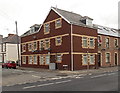
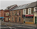
1
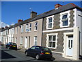
Treherbert Street
Terraced housing in inner city Cardiff. This area, Cathays, now has a large student population, being near to Cardiff and Glamorgan University buildings.
Image: © Colin Smith
Taken: 15 Sep 2007
0.03 miles
2

Dalton Street Day Centre, Cathays, Cardiff
Located in a former church.
This is one of seven Cardiff Council day centres for older people, offering services such as personal care, social activities, laundry facilities, a hot meal and transport to the day centre.
Access to these services is via a social worker referral following a needs assessment. A financial assessment will also be undertaken and charges made in accordance with the outcome.
Image: © Jaggery
Taken: 15 Jul 2010
0.03 miles
3
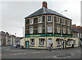
The Flora, Cardiff
Pub dating from the 19th century,on the corner of Cathays Terrace and Flora Street.
Image: © Jaggery
Taken: 15 Jul 2010
0.03 miles
4
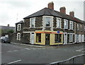
Cafelito, Cathays, Cardiff
Cafelito looks Spanish, so it probably means either a small cup of coffee, or a small cafe. Small cafe perfectly describes these premises on the corner of Dalton Street and Flora Street.
Image: © Jaggery
Taken: 15 Jul 2010
0.03 miles
5
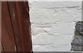
Ordnance Survey Cut Mark
This OS cut mark can be found on No16 Merthyr Street. It marks a point 18.398m above mean sea level.
Image: © Adrian Dust
Taken: 12 Oct 2017
0.03 miles
6
Treherbert Court, Cathays, Cardiff
Flats on the corner of Treherbert Street and Cathays Terrace.
Image: © Jaggery
Taken: 20 Oct 2013
0.04 miles
7
Hirwaun Street, Cathays
From the junction with Darran Street. At the far end is Image
Image: © Derek Harper
Taken: 16 Jun 2018
0.04 miles
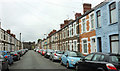
8
Treherbert Street, Cathays, Cardiff
Viewed across Cathays Terrace looking towards Merthyr Street.
Image: © Jaggery
Taken: 20 Oct 2013
0.05 miles
9
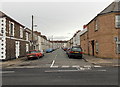
Treorky Street, Cathays, Cardiff
Viewed across Cathays Terrace looking towards Merthyr Street.
Treorky is an old version of the name of the village in the county borough of Rhondda Cynon Taf
known today in English as Treorchy (Treorci in Welsh).
Image: © Jaggery
Taken: 20 Oct 2013
0.05 miles
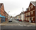
10
Adams Fish Bar & Punjabi Balti House, Cathays, Cardiff
Viewed across Cathays Terrace near the corner of Treherbert Street (on the left).
Image: © Jaggery
Taken: 20 Oct 2013
0.05 miles