IMAGES TAKEN NEAR TO
Pen-y-Wain Road, CARDIFF, CF24 4GB
Introduction
This page details the photographs taken nearby to Pen-y-Wain Road, CF24 4GB by members of the Geograph project.
The Geograph project started in 2005 with the aim of publishing, organising and preserving representative images for every square kilometre of Great Britain, Ireland and the Isle of Man.

There are currently over 7.5m images from over14,400 individuals and you can help contribute to the project by visiting https://www.geograph.org.uk
Image Map
Images are licensed for reuse under creativecommons.org/licenses/by-sa/2.0
Notes
- Clicking on the map will re-center to the selected point.
- The higher the marker number, the further away the image location is from the centre of the postcode.
Image Listing (66 Images Found)
Images are licensed for reuse under creativecommons.org/licenses/by-sa/2.0
Image
Details
Distance
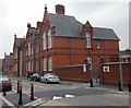
1

Ordnance Survey Cut Mark
This OS cut mark can be found on No11 Pen Y Wain Road. It marks a point 16.715m above mean sea level.
Image: © Adrian Dust
Taken: 11 Nov 2017
0.01 miles
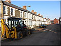
2

Werfa Street, Roath, Cardiff
Houses on the west side of the street, viewed from the corner of Ninian Road.
In the distance is Roath Park Primary School. http://www.geograph.org.uk/photo/1808379
Image: © Jaggery
Taken: 14 Apr 2010
0.02 miles
3

Ordnance Survey Cut Mark
This OS cut mark can be found on the NE face of Roath Park School. It marks a point 15.908m above mean sea level.
Image: © Adrian Dust
Taken: 11 Nov 2017
0.03 miles
6
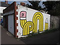
Street art: off Pen-y-Wain Road, Cardiff
Image: © Gareth James
Taken: 5 Sep 2014
0.07 miles
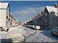
7
Roath Park Primary School, Cardiff
Located on Pen-y-Wain Road, Roath, opposite Werfa Street.
The school was built during 1894 and officially opened in January 1895. It was originally designed to accommodate about 1250 pupils. There are currently about 400 pupils enrolled.
Image: © Jaggery
Taken: 14 Apr 2010
0.07 miles
8

Ordnance Survey Cut Mark
This OS cut mark can be found on No51 Ninian Road. It marks a point 15.075m above mean sea level.
Image: © Adrian Dust
Taken: 11 Nov 2017
0.07 miles
9
Ordnance Survey Cut Mark
This OS cut mark can be found on No1 Pen Y Wain Road. It marks a point 15.767m above mean sea level.
Image: © Adrian Dust
Taken: 11 Nov 2017
0.09 miles
10

Construction work in Roath Park Rec
Stretching across what was previously grass is an under-construction cycle path and footway.
Image: © Gareth James
Taken: 29 Jun 2024
0.09 miles