IMAGES TAKEN NEAR TO
May Street, CARDIFF, CF24 4EX
Introduction
This page details the photographs taken nearby to May Street, CF24 4EX by members of the Geograph project.
The Geograph project started in 2005 with the aim of publishing, organising and preserving representative images for every square kilometre of Great Britain, Ireland and the Isle of Man.

There are currently over 7.5m images from over14,400 individuals and you can help contribute to the project by visiting https://www.geograph.org.uk
Image Map
Images are licensed for reuse under creativecommons.org/licenses/by-sa/2.0
Notes
- Clicking on the map will re-center to the selected point.
- The higher the marker number, the further away the image location is from the centre of the postcode.
Image Listing (128 Images Found)
Images are licensed for reuse under creativecommons.org/licenses/by-sa/2.0
Image
Details
Distance
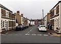
1
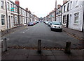
Blocked part of May Street, Cathays, Cardiff
Looking NW from the corner of Fanny Street.
Image: © Jaggery
Taken: 20 Oct 2013
0.02 miles
2
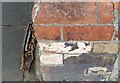
Ordnance Survey Cut Mark
This OS cut mark can be found on the Salvation Army Hall. It marks a point 17.005m above mean sea level.
Image: © Adrian Dust
Taken: 12 Oct 2017
0.02 miles
5
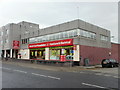
British Heart Foundation shop, Crwys Road, Cardiff
Charity shop selling furniture and electrical items, located on the corner of Crwys Road and Fanny Street. The premises were formerly occupied by Heli-Beds.
Image: © Jaggery
Taken: 15 Jul 2010
0.04 miles
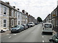
6
Fanny Street north of Crwys Road, Cardiff
Fanny Street heads away from Crwys Road, past the British Heart Foundation shop on the lefthttp://www.geograph.org.uk/photo/1974452
The tree in the distance prevents vehicular access into Daniel Street from Fanny Street. Fanny Street continues on the other side of Daniel Street, ending at the corner of Gwynneth Street and Spencer Street.
Image: © Jaggery
Taken: 15 Jul 2010
0.04 miles
7
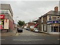
Crwys Road post office, Cardiff
Post office located on the (very busy!) corner of Crwys Road and Dalton Street, in the Cathays area of Cardiff.
Image: © Jaggery
Taken: 15 Jul 2010
0.04 miles
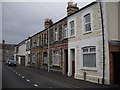
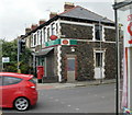
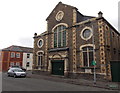
8
Salvation Army, Cathays, Cardiff
Cardiff Cathays Corps building on the corner of May Street and Fanny Street.
Image: © Jaggery
Taken: 15 Jul 2010
0.05 miles
9
Gladys Street, Cathays, Cardiff
Viewed across May Street looking towards Minny Street.
Image: © Jaggery
Taken: 20 Oct 2013
0.05 miles
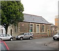
10
Minny Street chapel, Cardiff
This is the Fanny Street side of the chapel on the corner of Minny Street. The large chapel in the Classical style was built as Minny Street Independent Chapel in 1887, enlarged in 1904 and restored in 1927. These details are in Welsh inscriptions in stone above the door.
Image: © Jaggery
Taken: 20 Oct 2013
0.06 miles