1
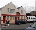
Minny Street chapel, Cardiff
This is the Fanny Street side of the chapel on the corner of Minny Street. The large chapel in the Classical style was built as Minny Street Independent Chapel in 1887, enlarged in 1904 and restored in 1927. These details are in Welsh inscriptions in stone above the door.
Image: © Jaggery
Taken: 20 Oct 2013
0.02 miles
2
Eglwys Minny Street, Cardiff
Image: © John Lord
Taken: 30 Jul 2011
0.03 miles
3
Eglwys Minny Street, Cardiff
Welsh chapel.
Image: © John Lord
Taken: 30 Jul 2011
0.03 miles
4
Ordnance Survey Cut Mark
This OS cut mark can be found on the chapel, Fanny Street. It marks a point 17.221m above mean sea level.
Image: © Adrian Dust
Taken: 12 Oct 2017
0.03 miles
5
Back to the Wood, Cardiff
Business selling paint strippers, located in Fanny Street between Minny Street and Flora Street.
Image: © Jaggery
Taken: 20 Oct 2013
0.03 miles
6
St Andrew & St Teilo, Cathays, Cardiff
The Church in Wales church is on the corner of Flora Street and Woodville Road, in the Parish of Cathays, Llandaff Diocese.
Image: © Jaggery
Taken: 20 Oct 2013
0.05 miles
7
Ordnance Survey Cut Mark
This very damaged OS cut mark can be found on the wall NW side of Woodville Road. It marks a point 16.682m above mean sea level.
Image: © Adrian Dust
Taken: 12 Oct 2017
0.05 miles
8
Kama Lounge, Cathays, Cardiff
Cafe bar and takeaway on the corner of Woodville Road and Basil Place.
Image: © Jaggery
Taken: 20 Oct 2013
0.05 miles
9
The Old & New Testament Church of God, Cardiff
Located in May Street in the Cathays area of Cardiff.
Image: © Jaggery
Taken: 20 Oct 2013
0.05 miles
10
Ordnance Survey Cut Mark
This OS cut mark can be found on the Salvation Army Hall. It marks a point 17.005m above mean sea level.
Image: © Adrian Dust
Taken: 12 Oct 2017
0.05 miles


