IMAGES TAKEN NEAR TO
Woodville Road, CARDIFF, CF24 4DX
Introduction
This page details the photographs taken nearby to Woodville Road, CF24 4DX by members of the Geograph project.
The Geograph project started in 2005 with the aim of publishing, organising and preserving representative images for every square kilometre of Great Britain, Ireland and the Isle of Man.

There are currently over 7.5m images from over14,400 individuals and you can help contribute to the project by visiting https://www.geograph.org.uk
Image Map
Images are licensed for reuse under creativecommons.org/licenses/by-sa/2.0
Notes
- Clicking on the map will re-center to the selected point.
- The higher the marker number, the further away the image location is from the centre of the postcode.
Image Listing (148 Images Found)
Images are licensed for reuse under creativecommons.org/licenses/by-sa/2.0
Image
Details
Distance
1
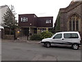
St Teilo's Vicarage, Cathays, Cardiff
Located in Flora Street, alongside the church. http://www.geograph.org.uk/photo/3707842
Image: © Jaggery
Taken: 20 Oct 2013
0.02 miles
2
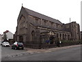
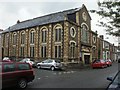
St Andrew & St Teilo, Cathays, Cardiff
The Church in Wales church is on the corner of Flora Street and Woodville Road, in the Parish of Cathays, Llandaff Diocese.
Image: © Jaggery
Taken: 20 Oct 2013
0.03 miles
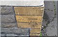
3
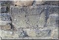
Ordnance Survey Cut Mark
This very damaged OS cut mark can be found on the wall NW side of Woodville Road. It marks a point 16.682m above mean sea level.
Image: © Adrian Dust
Taken: 12 Oct 2017
0.03 miles
4
Zi's Cafe, Cardiff
Chinese cuisine takeaway in Woodville Road.
Image: © Jaggery
Taken: 20 Oct 2013
0.04 miles
5
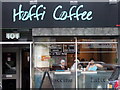
'Hoffi Coffi'
In Welsh '[I] like coffee': coffee bar in Woodville Road, Cathays.
Image: © Natasha Ceridwen de Chroustchoff
Taken: 29 Nov 2007
0.06 miles
6
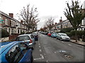
Two long lines of cars parked in Richards Street, Cathays, Cardiff
A typical Sunday scene in 2013 in this inner suburb of Cardiff. Viewed from the Mundy Place end looking NNE towards Rhymney Terrace.
Image: © Jaggery
Taken: 20 Oct 2013
0.06 miles
7
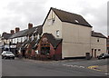
Kama Lounge, Cathays, Cardiff
Cafe bar and takeaway on the corner of Woodville Road and Basil Place.
Image: © Jaggery
Taken: 20 Oct 2013
0.06 miles
8
Ordnance Survey Cut Mark
This OS cut mark can be found on the chapel, Fanny Street. It marks a point 17.221m above mean sea level.
Image: © Adrian Dust
Taken: 12 Oct 2017
0.06 miles
9
Minny Street Welsh Independent Chapel, Cathays, Cardiff
Actually located a few metres beyond the SE end of Minny Street, on the corner of Fanny Street and Basil Place. The recent planting of trees at the end of Minny Street (a few branches are visible on the right), has blocked vehicular access, further isolating the chapel from its namesake.
The chapel was built in 1887.
Image: © Jaggery
Taken: 15 Jul 2010
0.07 miles
10
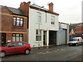
ACE MoT test centre, Fanny Street, Cardiff
Located at 11 Fanny Street, close to the Minny Street chapel. http://www.geograph.org.uk/photo/1973612
Image: © Jaggery
Taken: 15 Jul 2010
0.07 miles