IMAGES TAKEN NEAR TO
Rhymney Terrace, CARDIFF, CF24 4DE
Introduction
This page details the photographs taken nearby to Rhymney Terrace, CF24 4DE by members of the Geograph project.
The Geograph project started in 2005 with the aim of publishing, organising and preserving representative images for every square kilometre of Great Britain, Ireland and the Isle of Man.

There are currently over 7.5m images from over14,400 individuals and you can help contribute to the project by visiting https://www.geograph.org.uk
Image Map
Images are licensed for reuse under creativecommons.org/licenses/by-sa/2.0
Notes
- Clicking on the map will re-center to the selected point.
- The higher the marker number, the further away the image location is from the centre of the postcode.
Image Listing (135 Images Found)
Images are licensed for reuse under creativecommons.org/licenses/by-sa/2.0
Image
Details
Distance
1

Vintage treasures, going cheap
Basil Brush and other blasts from the past in a bric-a-brac shop in Crwys Road.
Image: © Natasha Ceridwen de Chroustchoff
Taken: 29 Nov 2007
0.02 miles
2
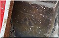
Ordnance Survey Cut Mark
This OS cut mark can be found on the Police Station wall. It marks a point 17.944m above mean sea level.
Image: © Adrian Dust
Taken: 12 Oct 2017
0.02 miles
3
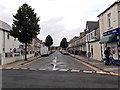
Harriet Street, Cathays, Cardiff
Viewed from the Wyeverne Road and Mundy Place end, looking NE towards Rhymney Terrace.
K&C Store Lifestyle Express is on the right.
Image: © Jaggery
Taken: 20 Oct 2013
0.03 miles
4
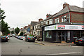
Richards Street, Cathays
Seen across the A469 Crwys Road.
Image: © Derek Harper
Taken: 16 Jun 2018
0.03 miles
5
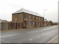
Former St Martin's Parish Hall, Cardiff
The only clue to the former usage of this apparently long-disused building on Crwys Road is a faded sign above a doorway on the far side of the building, formerly St Martin's Parish hall. A correspondent informed me that, in the late 1940s, the upstairs area of the hall was used by scouts, guides etc. Downstairs were a stage & hall used for plays etc.
St Martin's church http://www.geograph.org.uk/photo/625333 is a few hundred metres away.
Image: © Jaggery
Taken: 15 Jul 2010
0.03 miles
6
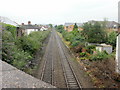
The view north from Crwys Road railway bridge, Cardiff
Near the SE end of Crwys Road, a bridge carries the road over the railway lines from Cardiff Queen Street station (behind the camera). The next station in this direction is Heath High Level, about 2½ kilometres (1½ miles) away.
Image: © Jaggery
Taken: 15 Jul 2010
0.03 miles
7
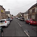
Rhymney Terrace, Cathays, Cardiff
Viewed from the Woodville Road end.
Image: © Jaggery
Taken: 20 Oct 2013
0.04 miles
8
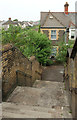
Steps beside railway bridge, Roath
Down from the A469 Crwys Road to Moy Road. Image] was taken just to the left.
Image: © Derek Harper
Taken: 16 Jun 2018
0.04 miles
9
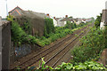
Railway line, Roath
The view on the other side of the A469 from Image], with the railway line to Merthyr Tydfil passing Alexander Street on the other side.
Image: © Derek Harper
Taken: 16 Jun 2018
0.04 miles
10
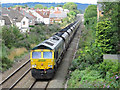
Coal train in Roath
A Cwmbargoed to Port Talbot Grange sidings loaded coal working heads through the Cardiff suburb of Roath in the hands of class 66 locomotive No. 66571.
Image: © Gareth James
Taken: 22 Aug 2018
0.05 miles