IMAGES TAKEN NEAR TO
Wyeverne Road, CARDIFF, CF24 4BG
Introduction
This page details the photographs taken nearby to Wyeverne Road, CF24 4BG by members of the Geograph project.
The Geograph project started in 2005 with the aim of publishing, organising and preserving representative images for every square kilometre of Great Britain, Ireland and the Isle of Man.

There are currently over 7.5m images from over14,400 individuals and you can help contribute to the project by visiting https://www.geograph.org.uk
Image Map
Images are licensed for reuse under creativecommons.org/licenses/by-sa/2.0
Notes
- Clicking on the map will re-center to the selected point.
- The higher the marker number, the further away the image location is from the centre of the postcode.
Image Listing (143 Images Found)
Images are licensed for reuse under creativecommons.org/licenses/by-sa/2.0
Image
Details
Distance
1
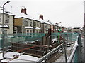
Deep excavations on Wyeverne Road, Cardiff
The road is currently shut for sewer works.
Image: © Gareth James
Taken: 19 Jan 2013
0.03 miles
2
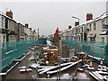
Roadworks on Wyeverne Road, Cardiff
The road is currently shut for sewer works.
Image: © Gareth James
Taken: 19 Jan 2013
0.03 miles
3
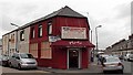
Zem Zem Continental Food, Cathays, Cardiff
Shop on the corner of Wyeverne Road and Thesiger Street.
Image: © Jaggery
Taken: 20 Oct 2013
0.04 miles
4
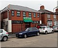
Dar Ul-Isra, Cathays, Cardiff
Muslim educational and welfare centre in Wyeverne Road.
Image: © Jaggery
Taken: 20 Oct 2013
0.05 miles
5
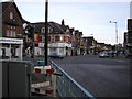
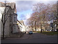
Junction of Crwys Road, Mackintosh Place, City Road, Richmond Road and Albany Road.
It's known locally as "Deaths junction" not because it's a hard place to cross ( as I used to think ) but hangings used to be carried out there.
Image: © Steve Chapple
Taken: 23 Aug 2005
0.05 miles
6
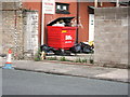
What a load of rubbish
Rear of the Old Blue Lamp Club...Jnc. of Woodville Rd and Basil Place
Image: © John Baker
Taken: 19 Aug 2006
0.05 miles
7
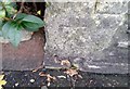
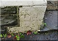
Ordnance Survey Cut Mark
This OS cut mark can be found on No29 Ruthin Gardens. It marks a point 15.752m above mean sea level.
Image: © Adrian Dust
Taken: 12 Oct 2017
0.05 miles
8
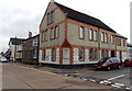
Cathays Conservative Club, Cardiff
On the corner of Wyeverne Road and Fitzroy Street. As well as a name sign
on the Wyeverne Road side of the building, the club's name is inscribed in the corner.
Image: © Jaggery
Taken: 20 Oct 2013
0.06 miles
9
Ruthin Gardens near to Cathays railway station
The trees in the centre of the square enhance this locality; the buildings are Victorian but still do what they are originally built for.
Image: © peter clayton
Taken: 14 Feb 2010
0.06 miles
10
Ordnance Survey Cut Mark
This OS cut mark can be found on No28 Llandough Street. It marks a point 15.895m above mean sea level.
Image: © Adrian Dust
Taken: 12 Oct 2017
0.06 miles