IMAGES TAKEN NEAR TO
Albany Road, CARDIFF, CF24 3RQ
Introduction
This page details the photographs taken nearby to Albany Road, CF24 3RQ by members of the Geograph project.
The Geograph project started in 2005 with the aim of publishing, organising and preserving representative images for every square kilometre of Great Britain, Ireland and the Isle of Man.

There are currently over 7.5m images from over14,400 individuals and you can help contribute to the project by visiting https://www.geograph.org.uk
Image Map
Images are licensed for reuse under creativecommons.org/licenses/by-sa/2.0
Notes
- Clicking on the map will re-center to the selected point.
- The higher the marker number, the further away the image location is from the centre of the postcode.
Image Listing (106 Images Found)
Images are licensed for reuse under creativecommons.org/licenses/by-sa/2.0
Image
Details
Distance
1
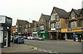
Albany Road, Roath
The A469 seen from the southern end of Arabella Street. Two pawnbrokers, two e-cigarette outlets.
Image: © Derek Harper
Taken: 16 Jun 2018
0.01 miles
2
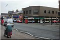
Albany Road post office, Cardiff
Located on the corner of Albany Road and Donald Street.
Image: © Jaggery
Taken: 15 Jul 2010
0.02 miles
3
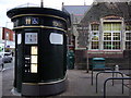
Toiled/toilet, Albany Road
Cardiff has invested in these state-of-the-art public conveniences for which you have to PAY unless someone kindly holds the door open for you. This one is at the junction of Plas Newydd Road. Note the net on top - to keep off pigeons?
Image: © Natasha Ceridwen de Chroustchoff
Taken: 29 Nov 2007
0.03 miles
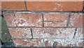
4
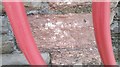
Ordnance Survey Cut Mark
This OS cut mark can be found on the inner west angle of the school. It marks a point 13.802m above mean sea level.
Image: © Adrian Dust
Taken: 12 Oct 2017
0.05 miles
5
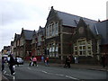
School, Albany Road
Albany Primary and Nursery school; formerly Albany Road Board School,1886.
This is the main street in a busy residential area at the lower end of the housing market.
Image: © Natasha Ceridwen de Chroustchoff
Taken: 29 Nov 2007
0.05 miles
6
Ordnance Survey Cut Mark
This OS cut mark can be found on the north angle of St Martin's Church. It marks a point 14.637m above mean sea level.
Image: © Adrian Dust
Taken: 12 Oct 2017
0.05 miles
7
Two minutes of hail ...
... and the streets of Cardiff are covered!
Image: © Gareth James
Taken: 13 Dec 2011
0.05 miles
8
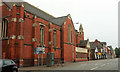
St Martin's church, Roath
On the A469 Albany Road, and shown from the other direction in Image The church is unlisted but described at https://en.wikipedia.org/wiki/St_Martin%27s_Church,_Roath : "founded as a tin tabernacle in 1886. The present building replaced it in 1901".
Image: © Derek Harper
Taken: 16 Jun 2018
0.07 miles
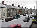
9
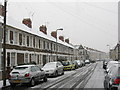
Arabella Street, Cardiff
Snowfall in Roath. The terraced houses are late-Victorian.
Image: © Gareth James
Taken: 9 Feb 2007
0.07 miles
10

Hairy caterpillar
Lackey Moth caterpillar (Malacosoma neustria)
Image: © Gareth James
Taken: 18 May 2014
0.07 miles