IMAGES TAKEN NEAR TO
Elm Street, CARDIFF, CF24 3RG
Introduction
This page details the photographs taken nearby to Elm Street, CF24 3RG by members of the Geograph project.
The Geograph project started in 2005 with the aim of publishing, organising and preserving representative images for every square kilometre of Great Britain, Ireland and the Isle of Man.

There are currently over 7.5m images from over14,400 individuals and you can help contribute to the project by visiting https://www.geograph.org.uk
Image Map (Loading...)


Getting Data...Please wait
Leaflet Map data © OpenStreetMap
Images are licensed for reuse under creativecommons.org/licenses/by-sa/2.0
Notes
- Clicking on the map will re-center to the selected point.
- The higher the marker number, the further away the image location is from the centre of the postcode.
Image Listing (79 Images Found)
Images are licensed for reuse under creativecommons.org/licenses/by-sa/2.0
Image
Details
Distance
1
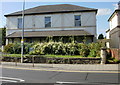
Ashcroft House, Roath, Cardiff
On the corner of Newport Road and Elm Street, Ashcroft House is a privately-owned residential care home.
Image: © Jaggery
Taken: 9 Sep 2009
0.02 miles
2
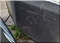
Ordnance Survey Cut Mark
This OS cut mark can be found on The Four Elms PH. It marks a point 12.305m above mean sea level.
Image: © Adrian Dust
Taken: 12 Oct 2017
0.03 miles
3

Graffiti mural. Cardiff
Graffiti mural in a lane off Elm street, Roath, Cardiff.
Image: © Steve Chapple
Taken: 21 Aug 2005
0.03 miles
4
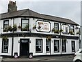
A lovely day for a Guinness
The Four Elms public house, Roath.
Image: © Alan Hughes
Taken: 14 May 2021
0.03 miles
6
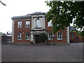
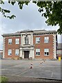
St Peter's R.C. Primary School, Cardiff
Formerly Cardiff High School for Boys. This block housed the staff-room, the library, form-rooms for 4th and 5th forms etc.
Image: © John Lord
Taken: 8 May 2010
0.04 miles
7
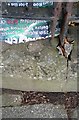
Ordnance Survey Rivet
This OS rivet can be found on the wall of Clifton Church, Newport Road. It marks a point 12.213m above mean sea level.
Image: © Adrian Dust
Taken: 12 Oct 2017
0.04 miles
8
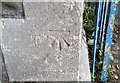
Ordnance Survey Cut Mark
This OS cut mark can be found on the Methodist Church, Four Elms Road. It marks a point 12.954m above mean sea level.
Image: © Adrian Dust
Taken: 12 Oct 2017
0.05 miles
9
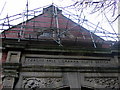
Library facade with literary cherub
Image: © Natasha Ceridwen de Chroustchoff
Taken: 29 Nov 2007
0.06 miles
10
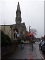
November afternoon in Cardiff
Looking west along Newport Road: the first spire belongs to yet another redundant church, on the corner of Upper Clifton Street, now an outlet for art and craft materials; the second marks Trinity Methodist church.
Image: © Natasha Ceridwen de Chroustchoff
Taken: 29 Nov 2007
0.06 miles