IMAGES TAKEN NEAR TO
Montgomery Street, CARDIFF, CF24 3LE
Introduction
This page details the photographs taken nearby to Montgomery Street, CF24 3LE by members of the Geograph project.
The Geograph project started in 2005 with the aim of publishing, organising and preserving representative images for every square kilometre of Great Britain, Ireland and the Isle of Man.

There are currently over 7.5m images from over14,400 individuals and you can help contribute to the project by visiting https://www.geograph.org.uk
Image Map
Images are licensed for reuse under creativecommons.org/licenses/by-sa/2.0
Notes
- Clicking on the map will re-center to the selected point.
- The higher the marker number, the further away the image location is from the centre of the postcode.
Image Listing (77 Images Found)
Images are licensed for reuse under creativecommons.org/licenses/by-sa/2.0
Image
Details
Distance
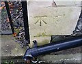
1
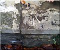
Ordnance Survey Rivet
This OS rivet can be found on the wall between Nos32 & 31 Ninian Road. It marks a point 13.326m above mean sea level.
Image: © Adrian Dust
Taken: 19 Nov 2017
0.03 miles
2
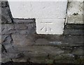
Ordnance Survey Cut Mark
This OS cut mark can be found on No1 Pen Y Wain Road. It marks a point 15.767m above mean sea level.
Image: © Adrian Dust
Taken: 11 Nov 2017
0.04 miles
3
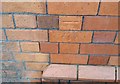
Ordnance Survey Cut Mark
This OS cut mark can be found on No40 Ninian Road. It marks a point 14.124m above mean sea level.
Image: © Adrian Dust
Taken: 19 Nov 2017
0.05 miles
4
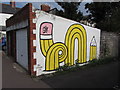
Street art: off Pen-y-Wain Road, Cardiff
Image: © Gareth James
Taken: 5 Sep 2014
0.06 miles
5

Construction of new path and cycle lane across Roath Park Recreation Ground
Image: © Gareth James
Taken: 29 Mar 2024
0.06 miles
6

Golden path
Autumn-coloured beech trees line the path between Ninian Road and Roath Recreation Ground in Cardiff. A December bonus in one of the warmest years on record.
Image: © Alan Hughes
Taken: 1 Dec 2022
0.07 miles
7
Ordnance Survey Cut Mark
This OS cut mark can be found on No17 Ninian Road. It marks a point 12.921m above mean sea level.
Image: © Adrian Dust
Taken: 19 Nov 2017
0.08 miles
8

Diana Street, Roath
From the crossroads shown in Image At the end is the listed Roath Park Primary School http://ishare.cardiff.gov.uk/Projects/Cadw/CardiffListedBuildings/25863.pdf ; see also Image
Image: © Derek Harper
Taken: 16 Jun 2018
0.08 miles
9
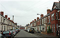
Alfred Street, Roath
Between Moy Road and Dalcross Street.
Image: © Derek Harper
Taken: 16 Jun 2018
0.08 miles
10
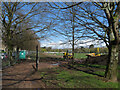
Construction of new path and cycle lane across Roath Park Recreation Ground
Image: © Gareth James
Taken: 29 Mar 2024
0.09 miles