IMAGES TAKEN NEAR TO
Wordsworth Avenue, CARDIFF, CF24 3FQ
Introduction
This page details the photographs taken nearby to Wordsworth Avenue, CF24 3FQ by members of the Geograph project.
The Geograph project started in 2005 with the aim of publishing, organising and preserving representative images for every square kilometre of Great Britain, Ireland and the Isle of Man.

There are currently over 7.5m images from over14,400 individuals and you can help contribute to the project by visiting https://www.geograph.org.uk
Image Map
Images are licensed for reuse under creativecommons.org/licenses/by-sa/2.0
Notes
- Clicking on the map will re-center to the selected point.
- The higher the marker number, the further away the image location is from the centre of the postcode.
Image Listing (105 Images Found)
Images are licensed for reuse under creativecommons.org/licenses/by-sa/2.0
Image
Details
Distance
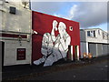
1
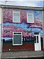
Hurricane mural
The mural honours Sgt Samuel Butterfield.
Image: © Alan Hughes
Taken: 14 May 2021
0.09 miles
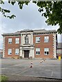
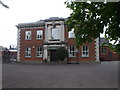
2
Former Cardiff Sixth Form College building
Image: © Martin Speck
Taken: 17 Apr 2013
0.09 miles
3
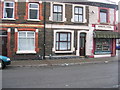
Terraced Street, Roath
Typical terraced street in a student area of the city, complete with corner shop.
Image: © Nicola Tanner
Taken: 24 Mar 2005
0.09 miles
5
St Peter's R.C. Primary School, Cardiff
Formerly Cardiff High School for Boys. This block housed the staff-room, the library, form-rooms for 4th and 5th forms etc.
Image: © John Lord
Taken: 8 May 2010
0.11 miles
6
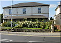
Ashcroft House, Roath, Cardiff
On the corner of Newport Road and Elm Street, Ashcroft House is a privately-owned residential care home.
Image: © Jaggery
Taken: 9 Sep 2009
0.11 miles
7
Street art: Shakespeare Street, Cardiff
Image: © Gareth James
Taken: 8 Dec 2013
0.12 miles
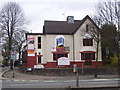
8
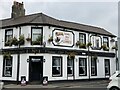
A lovely day for a Guinness
The Four Elms public house, Roath.
Image: © Alan Hughes
Taken: 14 May 2021
0.12 miles
9
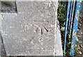
Ordnance Survey Cut Mark
This OS cut mark can be found on the Methodist Church, Four Elms Road. It marks a point 12.954m above mean sea level.
Image: © Adrian Dust
Taken: 12 Oct 2017
0.13 miles
10
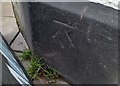
Ordnance Survey Cut Mark
This OS cut mark can be found on The Four Elms PH. It marks a point 12.305m above mean sea level.
Image: © Adrian Dust
Taken: 12 Oct 2017
0.13 miles