IMAGES TAKEN NEAR TO
City Road, CARDIFF, CF24 3DR
Introduction
This page details the photographs taken nearby to City Road, CF24 3DR by members of the Geograph project.
The Geograph project started in 2005 with the aim of publishing, organising and preserving representative images for every square kilometre of Great Britain, Ireland and the Isle of Man.

There are currently over 7.5m images from over14,400 individuals and you can help contribute to the project by visiting https://www.geograph.org.uk
Image Map
Images are licensed for reuse under creativecommons.org/licenses/by-sa/2.0
Notes
- Clicking on the map will re-center to the selected point.
- The higher the marker number, the further away the image location is from the centre of the postcode.
Image Listing (104 Images Found)
Images are licensed for reuse under creativecommons.org/licenses/by-sa/2.0
Image
Details
Distance
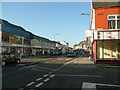
1
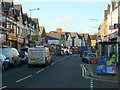
City Road, Roath, Cardiff
Looking north on this busy thoroughfare leading north from the city centre.
Image: © Jonathan Billinger
Taken: 11 Nov 2008
0.02 miles
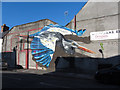
2
Street art: City Road, Cardiff
Four hens have appeared on a hoarding that hides the site of retail premises being demolished on City Road, Cardiff.
Image: © Gareth James
Taken: 15 Dec 2013
0.04 miles
3
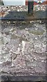
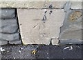
Ordnance Survey Rivet
This damaged OS rivet can be found on the wall of No14 Arran Street. It marks a point 14.935m above mean sea level.
Image: © Adrian Dust
Taken: 12 Oct 2017
0.04 miles
4
City Road, Cardiff
One of the arterial roads leading north away from the city centre.
Image: © Jonathan Billinger
Taken: 11 Nov 2008
0.05 miles
5
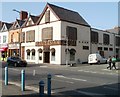
The Roath Park: scheduled for demolition
The former Roath Park public house, on the corner of City Road and Kincraig Street in Cardiff, has recently been approved by the local council for demolition.
Image: © Gareth James
Taken: 21 Nov 2021
0.05 miles
6
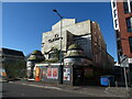
Former Gaiety Cinema
The former Gaiety Cinema, more recently the Spin Bowling Alley, has been derelict for many years now and presents a sad sight on City Road in Cardiff.
Image: © Gareth James
Taken: 20 Mar 2022
0.06 miles
7
Ordnance Survey Cut Mark
This OS cut mark can be found on the NW face of No167 City Road. It marks a point 10.296m above mean sea level.
Image: © Adrian Dust
Taken: 12 Oct 2017
0.06 miles
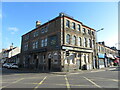
8
Can Zaman, Cardiff
Located at 116-118 City Road, on the corner of Pearson Street. The restaurant serves Middle Eastern cuisine, specialising in Lebanese and Syrian.
Image: © Jaggery
Taken: 10 Apr 2011
0.08 miles