IMAGES TAKEN NEAR TO
St. Peters Street, CARDIFF, CF24 3AZ
Introduction
This page details the photographs taken nearby to St. Peters Street, CF24 3AZ by members of the Geograph project.
The Geograph project started in 2005 with the aim of publishing, organising and preserving representative images for every square kilometre of Great Britain, Ireland and the Isle of Man.

There are currently over 7.5m images from over14,400 individuals and you can help contribute to the project by visiting https://www.geograph.org.uk
Image Map
Images are licensed for reuse under creativecommons.org/licenses/by-sa/2.0
Notes
- Clicking on the map will re-center to the selected point.
- The higher the marker number, the further away the image location is from the centre of the postcode.
Image Listing (170 Images Found)
Images are licensed for reuse under creativecommons.org/licenses/by-sa/2.0
Image
Details
Distance
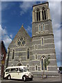
1
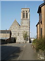
SW side of St Peter's church, Cardiff
The view NE along St Peter's Street. The church, archdiocese of Cardiff, is the oldest remaining Roman Catholic church in Cardiff. The foundation stone was laid in August 1860. The church opened for worship in September 1861.
Image: © Jaggery
Taken: 10 Apr 2011
0.02 miles
2
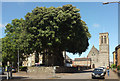
Junction on Richmond Road, Cardiff
On the right is the grade II* listed Church of St Peter http://ishare.cardiff.gov.uk/Projects/Cadw/CardiffListedBuildings/13805.pdf , "Built 1860-1 by C.F. Hansom ... in French C13 Gothic style".
Image: © Derek Harper
Taken: 16 Jun 2018
0.02 miles
4
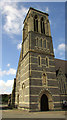
Church, Cardiff
The grade II* listed Church of St Peter http://ishare.cardiff.gov.uk/Projects/Cadw/CardiffListedBuildings/13805.pdf , "Built 1860-1 by C.F. Hansom ... in French C13 Gothic style".
Image: © Derek Harper
Taken: 16 Jun 2018
0.02 miles
5
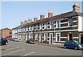
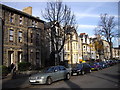
St Peter's Street, Cardiff
A long row of houses on the south side of the street, facing the Catholic church. http://www.geograph.org.uk/photo/2351855
Image: © Jaggery
Taken: 10 Apr 2011
0.05 miles
6
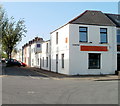
Cardiff Buddhist Centre
Located on the corner of St Peter's Street and Bedford Street (ahead).
Image: © Jaggery
Taken: 10 Apr 2011
0.05 miles
7
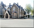
St Peter's Presbytery, Cardiff
The presbytery (priests' house) is located on the corner of St Peter's Street and Bedford Street, opposite the Buddhist Centre. http://www.geograph.org.uk/photo/2351865 The edge of St Peter's Roman Catholic church http://www.geograph.org.uk/photo/2351855 is on the left.
The presbytery (and surrounding railings) were Grade II listed in 2002.
Image: © Jaggery
Taken: 10 Apr 2011
0.05 miles
8
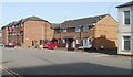
St Peter's Court, Cardiff
Housing on the corner of St Peter's Street and Bedford Place.
Image: © Jaggery
Taken: 10 Apr 2011
0.05 miles
10
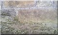
Ordnance Survey Cut Mark
This OS cut mark can be found on the wall SE side of The Walk. It marks a point 12.375m above mean sea level.
Image: © Adrian Dust
Taken: 1 Oct 2017
0.05 miles