IMAGES TAKEN NEAR TO
Richmond Road, CARDIFF, CF24 3AR
Introduction
This page details the photographs taken nearby to Richmond Road, CF24 3AR by members of the Geograph project.
The Geograph project started in 2005 with the aim of publishing, organising and preserving representative images for every square kilometre of Great Britain, Ireland and the Isle of Man.

There are currently over 7.5m images from over14,400 individuals and you can help contribute to the project by visiting https://www.geograph.org.uk
Image Map (Loading...)


Getting Data...Please wait
Leaflet Map data © OpenStreetMap
Images are licensed for reuse under creativecommons.org/licenses/by-sa/2.0
Notes
- Clicking on the map will re-center to the selected point.
- The higher the marker number, the further away the image location is from the centre of the postcode.
Image Listing (132 Images Found)
Images are licensed for reuse under creativecommons.org/licenses/by-sa/2.0
Image
Details
Distance
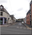
1
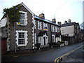
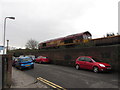
Gordon Rd, Cardiff
The O.S. 1:50000 map shows Gordon Rd coming to a dead end at its northern end. In fact,at the point in the photograph,it bends through a right angle eastward to join Richmond Rd.
Image: © John Lord
Taken: 7 Jan 2011
0.02 miles
2
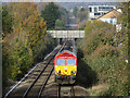
Coal train in Cathays
A loaded coal train from Cwmbargoed to Margam descends towards Queen Street North Junction, Cardiff, with class 66 locomotive No. 66066 in charge.
Image: © Gareth James
Taken: 19 Nov 2022
0.06 miles
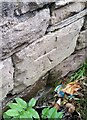
3
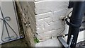
Ordnance Survey Cut Mark
This OS cut mark can be found on No21 Gordon Road. It marks a point 13.347m above mean sea level.
Image: © Adrian Dust
Taken: 12 Oct 2017
0.06 miles
4
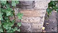
Ordnance Survey Cut Mark
This OS cut mark can be found on the wall of No33 Richmond Road. It marks a point 12.905m above mean sea level.
Image: © Adrian Dust
Taken: 12 Oct 2017
0.06 miles
5
Gordon Road, Cardiff
A class 66 locomotive passes beside Gordon Road, with an engineers' train bound for Crewe.
Image: © Gareth James
Taken: 14 Apr 2013
0.07 miles
6
Ordnance Survey Cut Mark
This OS cut mark can be found on the wall west side of Gordon Road. It marks a point 13.759m above mean sea level.
Image: © Adrian Dust
Taken: 12 Oct 2017
0.07 miles
7
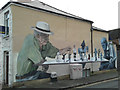
Street art, Cardiff
Some newly-arrived street art on the corner of Northcote Lane and Bedford Street - and very fine it looks too!
Image: © Gareth James
Taken: 14 Dec 2014
0.08 miles
8
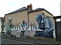
Street art, Cardiff
A board game being played out on the corner of Northgate Lane and Bedford Street.
Image: © Gareth James
Taken: 14 Dec 2014
0.08 miles
9
Cranbrook Street, Cathays, Cardiff
Viewed across Salisbury Road. Cranbrook Street bends to the left ahead, at a railway perimeter fence.
Image: © Jaggery
Taken: 20 Oct 2013
0.08 miles
10
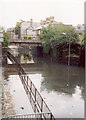
Flooding in Cardiff
The flooding under Lowther Road railway bridge must have been over 2 metres high at its deepest point.
Image: © Gareth James
Taken: Unknown
0.08 miles