IMAGES TAKEN NEAR TO
East Grove, CARDIFF, CF24 3AE
Introduction
This page details the photographs taken nearby to East Grove, CF24 3AE by members of the Geograph project.
The Geograph project started in 2005 with the aim of publishing, organising and preserving representative images for every square kilometre of Great Britain, Ireland and the Isle of Man.

There are currently over 7.5m images from over14,400 individuals and you can help contribute to the project by visiting https://www.geograph.org.uk
Image Map
Images are licensed for reuse under creativecommons.org/licenses/by-sa/2.0
Notes
- Clicking on the map will re-center to the selected point.
- The higher the marker number, the further away the image location is from the centre of the postcode.
Image Listing (156 Images Found)
Images are licensed for reuse under creativecommons.org/licenses/by-sa/2.0
Image
Details
Distance
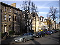
2
Tree with obesity problem
East Grove, Cardiff
Image: © John Lord
Taken: 24 Nov 2010
0.02 miles
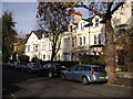
3
St Peter's Street, Cardiff
A long row of houses on the south side of the street, facing the Catholic church. http://www.geograph.org.uk/photo/2351855
Image: © Jaggery
Taken: 10 Apr 2011
0.03 miles
4
Cardiff Buddhist Centre
Located on the corner of St Peter's Street and Bedford Street (ahead).
Image: © Jaggery
Taken: 10 Apr 2011
0.03 miles
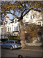
5
St Peter's Presbytery, Cardiff
The presbytery (priests' house) is located on the corner of St Peter's Street and Bedford Street, opposite the Buddhist Centre. http://www.geograph.org.uk/photo/2351865 The edge of St Peter's Roman Catholic church http://www.geograph.org.uk/photo/2351855 is on the left.
The presbytery (and surrounding railings) were Grade II listed in 2002.
Image: © Jaggery
Taken: 10 Apr 2011
0.03 miles
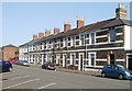
6
St Peter's Court, Cardiff
Housing on the corner of St Peter's Street and Bedford Place.
Image: © Jaggery
Taken: 10 Apr 2011
0.03 miles
7
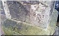
Ordnance Survey Cut Mark
This OS cut mark can be found on the gatepost of the Baptist Church. It marks a point 11.805m above mean sea level.
Image: © Adrian Dust
Taken: 1 Oct 2017
0.05 miles
8
The Municipal Club, Cardiff
The club, also known as The Muni, is at 11-13 City Road, on the north side of the Coleg Glan Hafren building. http://www.geograph.org.uk/photo/2351758 The full name of the club, founded in 1938, is Cardiff General and Municipal Workers Club & Institute Ltd.
Image: © Jaggery
Taken: 10 Apr 2011
0.05 miles
9
Two tandoori restaurants, City Road, Cardiff
Nearest the camera at 40 City Road is Radhuny, Indian tandoori restaurant. Next door is Tanvir Tandoori, contemporary Indian and Indonesian cuisine. The Tanvir premises were formerly Hazha Kurdish Restaurant.
On the north side of the turning into Vere Street is Machine Mart.
Image: © Jaggery
Taken: 10 Apr 2011
0.05 miles