1
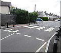
Mervyn Road, Tremorfa, Cardiff
East along Mervyn Road from Muirton Road towards Meredith Road, Madoc Road and Mercia Road.
Image: © Jaggery
Taken: 16 Jun 2017
0.03 miles
2
Ordnance Survey Cut Mark
This OS cut mark can be found on No18 Muirton Road. It marks a point 8.797m above mean sea level.
Image: © Adrian Dust
Taken: 16 Mar 2018
0.10 miles
3
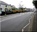
Zebra crossing on a Muirton Road hump, Tremorfa, Cardiff
Painted white triangles draw attention to the hump. The blue van is on the corner of Mervyn Road.
Image: © Jaggery
Taken: 16 Jun 2017
0.11 miles
4
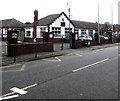
Baden Powell Primary School, Tremorfa, Cardiff
Viewed across Muirton Road.
Image: © Jaggery
Taken: 16 Jun 2017
0.11 miles
5
Houses and a school, Muirton Road, Tremorfa, Cardiff
Towards Baden Powell Primary School. http://www.geograph.org.uk/photo/5435273
Image: © Jaggery
Taken: 16 Jun 2017
0.11 miles
6
West side of Baden Powell Primary School, Tremorfa, Cardiff
Viewed across Muirton Road.
Image: © Jaggery
Taken: 16 Jun 2017
0.11 miles
7
Western Power Distribution electricity substation at the edge of Splott Park, Cardiff
The dark green cabinet is alongside a path between Splott Park and Muirton Road.
Image: © Jaggery
Taken: 16 Jun 2017
0.12 miles
8
Willows High School, Cardiff
Located on the NE side of Willows Avenue, viewed from Seawall Road.
The school has about 900 pupils, from the Splott, Adamsdown and Tremorfa areas of Cardiff.
Image: © Jaggery
Taken: 3 Sep 2010
0.12 miles
9
Splott Park public toilets, Cardiff
At the eastern edge of the park near Muirton Road.
Image: © Jaggery
Taken: 16 Jun 2017
0.12 miles
10
Southeast corner of The Hub, Splott, Cardiff
The Hub (Yr Hyb in Welsh) is a leisure centre in Splott Park, set back from Muirton Road.
Image: © Jaggery
Taken: 16 Jun 2017
0.13 miles


