IMAGES TAKEN NEAR TO
Muirton Road, CARDIFF, CF24 2SN
Introduction
This page details the photographs taken nearby to Muirton Road, CF24 2SN by members of the Geograph project.
The Geograph project started in 2005 with the aim of publishing, organising and preserving representative images for every square kilometre of Great Britain, Ireland and the Isle of Man.

There are currently over 7.5m images from over14,400 individuals and you can help contribute to the project by visiting https://www.geograph.org.uk
Image Map
Images are licensed for reuse under creativecommons.org/licenses/by-sa/2.0
Notes
- Clicking on the map will re-center to the selected point.
- The higher the marker number, the further away the image location is from the centre of the postcode.
Image Listing (47 Images Found)
Images are licensed for reuse under creativecommons.org/licenses/by-sa/2.0
Image
Details
Distance
1
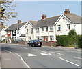
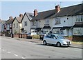
Muirton Road, Cardiff
Houses on the east side of Muirton Road, viewed from the Willows Avenue end.
There are no houses on the west side of the road, which is the perimeter of Splott Park. http://www.geograph.org.uk/photo/2050034
Image: © Jaggery
Taken: 3 Sep 2010
0.01 miles
2
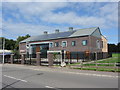
Cloughmore Medical Centre
The new medical centre is now almost complete.
Image: © Gareth James
Taken: 31 Aug 2013
0.04 miles
3
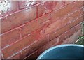
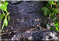
Ordnance Survey Cut Mark
This OS cut mark can be found on No44 Muirton Road. It marks a point 8.470m above mean sea level.
Image: © Adrian Dust
Taken: 16 Mar 2018
0.05 miles
4
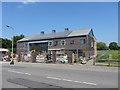
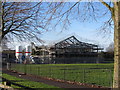
Construction of Cloughmore Medical Centre
Image: © Gareth James
Taken: 8 Jun 2013
0.05 miles
5
Construction of Cloughmore Medical Centre
Image: © Gareth James
Taken: 11 Jan 2013
0.05 miles
6
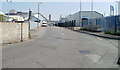
Seawall Road, Cardiff
Seawall Road heads away from South Park Road towards an industrial area.
Image: © Jaggery
Taken: 3 Sep 2010
0.05 miles
7
Willows Avenue, Cardiff
Houses on the south side of the avenue, viewed from the corner of Muirton Road.
Image: © Jaggery
Taken: 3 Sep 2010
0.06 miles
8
Railway bridges over South Park Road, Cardiff
Image: © Gareth James
Taken: 9 Jun 2010
0.06 miles
9
Ordnance Survey Cut Mark
This OS cut mark can be found on the north buttress of South Park Road Railway Bridge. It marks a point 6.182m above mean sea level.
Image: © Adrian Dust
Taken: 16 Mar 2018
0.07 miles
10
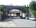
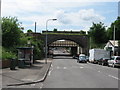
Two railways bridges, South Park Road, Cardiff
Looking west along South Park Road from near the Seawall Road junction.
The nearer, arched, bridge no longer carries railway tracks. The other bridge formerly carried six tracks, now reduced to two.
Image: © Jaggery
Taken: 3 Sep 2010
0.09 miles