1
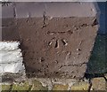
Ordnance Survey Cut Mark
This OS cut mark can be found on No150 Carlisle Street. It marks a point 10.741m above mean sea level.
Image: © Adrian Dust
Taken: 16 Mar 2018
0.03 miles
2
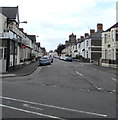
Railway Street, Cardiff
At the junction with Swinton Street (right), and at a slight bend in the prodigiously long terrace on the left, also shown in
Image
Image: © Derek Harper
Taken: 16 Jun 2018
0.07 miles
3
Cameron Street, Cardiff
Taken from its junction with Railway Street. The Roman Catholic Church of St Alban's On the Moors has scaffolding on its pyramidal roof. "Built 1911 by F R Bates ... Free perpendicular style ... Listed as relatively rare large-scale resourcefully-composed example of Roman Catholic church" http://ishare.cardiff.gov.uk/Projects/Cadw/CardiffListedBuildings/18291.pdf . The white building is the presbytery.
Image: © Derek Harper
Taken: 16 Jun 2018
0.07 miles
4
Ordnance Survey Cut Mark
This OS cut mark can be found on No172 Railway Street. It marks a point 10.531m above mean sea level.
Image: © Adrian Dust
Taken: 16 Mar 2018
0.08 miles
5
Railway Street, Cardiff
From the junction with Coveny Street. I think the terrace on the right runs to 116 properties, and is about 570 metres long. One of the longest ones in the country, I would imagine. A contributor on https://www.sabre-roads.org.uk/forum/viewtopic.php?t=30924 puts the number of houses at "well over 150"; but according to detailed maps, the numbering runs from 97 to 327, odd numbers only.
Image: © Derek Harper
Taken: 16 Jun 2018
0.08 miles
6
Habershon Street, Splott, Cardiff
Viewed from the corner of Moorland Road and North Park Road. Tackle-Mart http://www.geograph.org.uk/photo/5433193 is on the left.
Image: © Jaggery
Taken: 16 Jun 2017
0.10 miles
7
Ordnance Survey Cut Mark
This OS cut mark can be found on No113 Haberston Street. It marks a point 10.351m above mean sea level.
Image: © Adrian Dust
Taken: 16 Mar 2018
0.11 miles
8
Wilson Street houses, Splott, Cardiff
Viewed from Moorland Road.
Image: © Jaggery
Taken: 16 Jun 2017
0.11 miles
9
Carlisle Street, Splott, Cardiff
Looking to the SW along Carlisle Street from Moorland Road. Ema Balti is on the left. http://www.geograph.org.uk/photo/5433021
Image: © Jaggery
Taken: 16 Jun 2017
0.11 miles
10
Habershon Street, Splott, Cardiff
Viewed from the corner of Moorland Road and North Park Road.
The car is parked near the corner of Cameron Street.
Image: © Jaggery
Taken: 16 Jun 2017
0.12 miles


