IMAGES TAKEN NEAR TO
Railway Street, CARDIFF, CF24 2NH
Introduction
This page details the photographs taken nearby to Railway Street, CF24 2NH by members of the Geograph project.
The Geograph project started in 2005 with the aim of publishing, organising and preserving representative images for every square kilometre of Great Britain, Ireland and the Isle of Man.

There are currently over 7.5m images from over14,400 individuals and you can help contribute to the project by visiting https://www.geograph.org.uk
Image Map
Images are licensed for reuse under creativecommons.org/licenses/by-sa/2.0
Notes
- Clicking on the map will re-center to the selected point.
- The higher the marker number, the further away the image location is from the centre of the postcode.
Image Listing (131 Images Found)
Images are licensed for reuse under creativecommons.org/licenses/by-sa/2.0
Image
Details
Distance
1
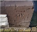
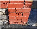
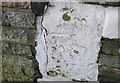
Ordnance Survey Cut Mark
This OS cut mark can be found on No172 Railway Street. It marks a point 10.531m above mean sea level.
Image: © Adrian Dust
Taken: 16 Mar 2018
0.01 miles
2
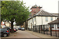
Cameron Street, Cardiff
Taken from its junction with Railway Street. The Roman Catholic Church of St Alban's On the Moors has scaffolding on its pyramidal roof. "Built 1911 by F R Bates ... Free perpendicular style ... Listed as relatively rare large-scale resourcefully-composed example of Roman Catholic church" http://ishare.cardiff.gov.uk/Projects/Cadw/CardiffListedBuildings/18291.pdf . The white building is the presbytery.
Image: © Derek Harper
Taken: 16 Jun 2018
0.02 miles
3
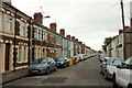
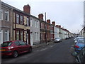
Railway Street, Cardiff
At the junction with Swinton Street (right), and at a slight bend in the prodigiously long terrace on the left, also shown in Image
Image: © Derek Harper
Taken: 16 Jun 2018
0.03 miles
4
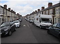
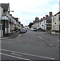
Railway Street, Splott, Cardiff
Looking to the SW along Railway Street from near the corner of Beresford Road and Moorland Road.
The backs of the houses on the right are opposite the South Wales main line railway.
Image: © Jaggery
Taken: 16 Jun 2017
0.03 miles
6
Carlisle Street, Splott, Cardiff
Looking to the SW along Carlisle Street from Moorland Road. Ema Balti is on the left. http://www.geograph.org.uk/photo/5433021
Image: © Jaggery
Taken: 16 Jun 2017
0.06 miles
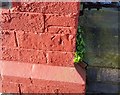
7
Ordnance Survey Cut Mark
This OS cut mark can be found on No218 Railway Street. It marks a point 10.586m above mean sea level.
Image: © Adrian Dust
Taken: 16 Mar 2018
0.07 miles
8
Ordnance Survey Cut Mark
This OS cut mark can be found on No150 Carlisle Street. It marks a point 10.741m above mean sea level.
Image: © Adrian Dust
Taken: 16 Mar 2018
0.08 miles
9
Ordnance Survey Cut Mark
This almost hidden OS cut mark can be found on No209 Carlisle Street. It marks a point 10.473m above mean sea level.
Image: © Adrian Dust
Taken: 16 Mar 2018
0.08 miles
10
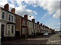
Wilson Street, Splott
The terrace housing in this road is typical of this area. Looking towards the north-west.
Image: © Linda Bailey
Taken: 3 Apr 2006
0.08 miles