IMAGES TAKEN NEAR TO
Habershon Street, CARDIFF, CF24 2JY
Introduction
This page details the photographs taken nearby to Habershon Street, CF24 2JY by members of the Geograph project.
The Geograph project started in 2005 with the aim of publishing, organising and preserving representative images for every square kilometre of Great Britain, Ireland and the Isle of Man.

There are currently over 7.5m images from over14,400 individuals and you can help contribute to the project by visiting https://www.geograph.org.uk
Image Map
Images are licensed for reuse under creativecommons.org/licenses/by-sa/2.0
Notes
- Clicking on the map will re-center to the selected point.
- The higher the marker number, the further away the image location is from the centre of the postcode.
Image Listing (72 Images Found)
Images are licensed for reuse under creativecommons.org/licenses/by-sa/2.0
Image
Details
Distance
1
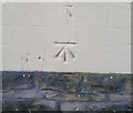
Ordnance Survey Cut Mark
This OS cut mark can be found on the NE face of the Methodist Church, Burnaby Street. It marks a point 10.604m above mean sea level.
Image: © Adrian Dust
Taken: 16 Mar 2018
0.03 miles
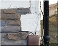
2
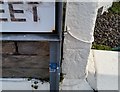
Ordnance Survey Cut Mark
This OS cut mark can be found on No113 Haberston Street. It marks a point 10.351m above mean sea level.
Image: © Adrian Dust
Taken: 16 Mar 2018
0.06 miles
3
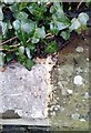
Ordnance Survey Rivet
This OS rivet can be found on the wall of No91 Splott Road. It marks a point 10.229m above mean sea level.
Image: © Adrian Dust
Taken: 16 Mar 2018
0.08 miles
6
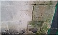
Ordnance Survey Cut Mark
This OS cut mark can be found on the west angle of St Saviours Church. It marks a point 11.006m above mean sea level.
Image: © Adrian Dust
Taken: 16 Mar 2018
0.10 miles
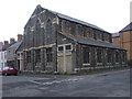
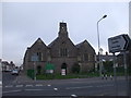
7
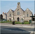
St Saviour's Church, Cardiff
Church in Wales church, viewed across Splott Road. The church was built in 1888.
Image: © Jaggery
Taken: 3 Sep 2010
0.11 miles
8
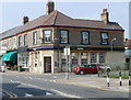
NatWest, Splott, Cardiff
Bank branch located at 41 Splott Road, on the corner of Carlisle Street.
Image: © Jaggery
Taken: 3 Sep 2010
0.11 miles
9
Ordnance Survey Cut Mark
This OS cut mark can be found on No118 Moorland Road. It marks a point 10.004m above mean sea level.
Image: © Adrian Dust
Taken: 16 Mar 2018
0.12 miles
10
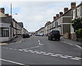
Habershon Street, Splott, Cardiff
Viewed from the corner of Moorland Road and North Park Road. Tackle-Mart http://www.geograph.org.uk/photo/5433193 is on the left.
Image: © Jaggery
Taken: 16 Jun 2017
0.13 miles